You are here: Home > Network List > TA - USArray Transportable Network (new EarthScope stations) Stations List
> Station J16K Anvik River, AK, USA > Earthquake Result Viewer
J16K Anvik River, AK, USA - Earthquake Result Viewer
| Earthquake location: |
Samar, Philippines |
| Earthquake latitude/longitude: |
12.0/124.1 |
| Earthquake time(UTC): |
2020/08/18 (231) 00:03:48 GMT |
| Earthquake Depth: |
10 km |
| Earthquake Magnitude: |
6.7 mww |
| Earthquake Catalog/Contributor: |
NEIC PDE/us |
|
| Network: |
TA USArray Transportable Network (new EarthScope stations) |
| Station: |
J16K Anvik River, AK, USA |
| Lat/Lon: |
63.28 N/160.60 W |
| Elevation: |
328 m |
|
| Distance: |
72.7 deg |
| Az: |
27.244 deg |
| Baz: |
262.288 deg |
| Ray Param: |
0.05347459 |
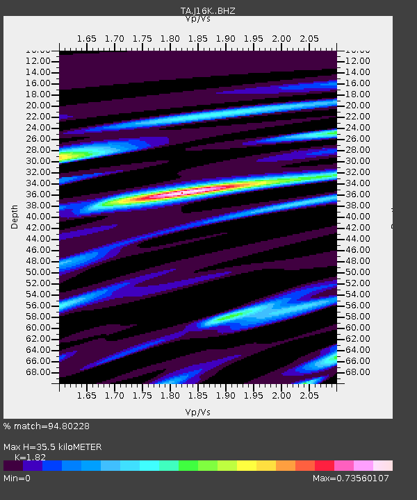
| Estimated Moho Depth: |
35.5 km |
| Estimated Crust Vp/Vs: |
1.82 |
| Assumed Crust Vp: |
6.276 km/s |
| Estimated Crust Vs: |
3.448 km/s |
| Estimated Crust Poisson's Ratio: |
0.28 |
|
| Radial Match: |
94.80228 % |
| Radial Bump: |
300 |
| Transverse Match: |
81.96405 % |
| Transverse Bump: |
375 |
| SOD ConfigId: |
21709731 |
| Insert Time: |
2020-09-01 00:17:03.617 +0000 |
| GWidth: |
2.5 |
| Max Bumps: |
400 |
| Tol: |
0.001 |
|

Signal To Noise
| Channel | StoN | STA | LTA |
| TA:J16K: :BHZ:20200818T00:14:45.850003Z | 6.9909606 | 4.1624173E-7 | 5.9539992E-8 |
| TA:J16K: :BHN:20200818T00:14:45.850003Z | 0.6475395 | 4.828535E-8 | 7.456742E-8 |
| TA:J16K: :BHE:20200818T00:14:45.850003Z | 2.2506478 | 1.394529E-7 | 6.1961224E-8 |
| Arrivals |
| Ps | 4.8 SECOND |
| PpPs | 15 SECOND |
| PsPs/PpSs | 20 SECOND |


