You are here: Home > Network List > TA - USArray Transportable Network (new EarthScope stations) Stations List
> Station J30M Hart River, Yukon, CAN > Earthquake Result Viewer
J30M Hart River, Yukon, CAN - Earthquake Result Viewer
| Earthquake location: |
Samar, Philippines |
| Earthquake latitude/longitude: |
12.0/124.1 |
| Earthquake time(UTC): |
2020/08/18 (231) 00:03:48 GMT |
| Earthquake Depth: |
10 km |
| Earthquake Magnitude: |
6.7 mww |
| Earthquake Catalog/Contributor: |
NEIC PDE/us |
|
| Network: |
TA USArray Transportable Network (new EarthScope stations) |
| Station: |
J30M Hart River, Yukon, CAN |
| Lat/Lon: |
64.58 N/136.33 W |
| Elevation: |
1419 m |
|
| Distance: |
83.3 deg |
| Az: |
25.378 deg |
| Baz: |
283.738 deg |
| Ray Param: |
0.04627582 |
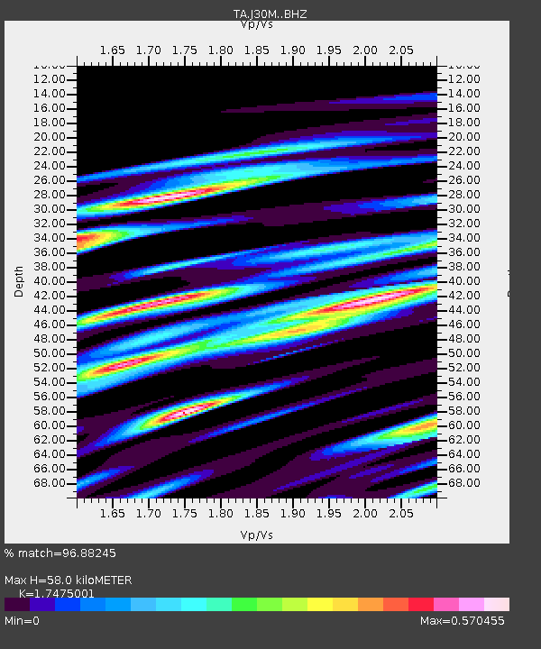
| Estimated Moho Depth: |
58.0 km |
| Estimated Crust Vp/Vs: |
1.75 |
| Assumed Crust Vp: |
6.566 km/s |
| Estimated Crust Vs: |
3.757 km/s |
| Estimated Crust Poisson's Ratio: |
0.26 |
|
| Radial Match: |
96.88245 % |
| Radial Bump: |
361 |
| Transverse Match: |
95.99584 % |
| Transverse Bump: |
344 |
| SOD ConfigId: |
21709731 |
| Insert Time: |
2020-09-01 00:17:07.129 +0000 |
| GWidth: |
2.5 |
| Max Bumps: |
400 |
| Tol: |
0.001 |
|

Signal To Noise
| Channel | StoN | STA | LTA |
| TA:J30M: :BHZ:20200818T00:15:44.375027Z | 3.8164892 | 2.8326716E-7 | 7.4221916E-8 |
| TA:J30M: :BHN:20200818T00:15:44.375027Z | 1.180982 | 7.744601E-8 | 6.557764E-8 |
| TA:J30M: :BHE:20200818T00:15:44.375027Z | 2.9535334 | 1.4448626E-7 | 4.8919798E-8 |
| Arrivals |
| Ps | 6.8 SECOND |
| PpPs | 24 SECOND |
| PsPs/PpSs | 30 SECOND |


