You are here: Home > Network List > TA - USArray Transportable Network (new EarthScope stations) Stations List
> Station M14K Bethel, AK, USA > Earthquake Result Viewer
M14K Bethel, AK, USA - Earthquake Result Viewer
| Earthquake location: |
Samar, Philippines |
| Earthquake latitude/longitude: |
12.0/124.1 |
| Earthquake time(UTC): |
2020/08/18 (231) 00:03:48 GMT |
| Earthquake Depth: |
10 km |
| Earthquake Magnitude: |
6.7 mww |
| Earthquake Catalog/Contributor: |
NEIC PDE/us |
|
| Network: |
TA USArray Transportable Network (new EarthScope stations) |
| Station: |
M14K Bethel, AK, USA |
| Lat/Lon: |
60.75 N/161.96 W |
| Elevation: |
19 m |
|
| Distance: |
71.8 deg |
| Az: |
29.795 deg |
| Baz: |
261.868 deg |
| Ray Param: |
0.05412801 |
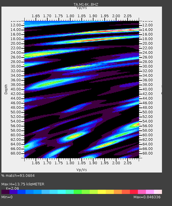
| Estimated Moho Depth: |
13.75 km |
| Estimated Crust Vp/Vs: |
2.06 |
| Assumed Crust Vp: |
6.182 km/s |
| Estimated Crust Vs: |
3.001 km/s |
| Estimated Crust Poisson's Ratio: |
0.35 |
|
| Radial Match: |
93.0684 % |
| Radial Bump: |
400 |
| Transverse Match: |
92.48533 % |
| Transverse Bump: |
390 |
| SOD ConfigId: |
21709731 |
| Insert Time: |
2020-09-01 00:17:23.138 +0000 |
| GWidth: |
2.5 |
| Max Bumps: |
400 |
| Tol: |
0.001 |
|

Signal To Noise
| Channel | StoN | STA | LTA |
| TA:M14K: :BHZ:20200818T00:14:39.975003Z | 4.8250012 | 5.2273674E-7 | 1.08339194E-7 |
| TA:M14K: :BHN:20200818T00:14:39.975003Z | 1.1896129 | 1.5461751E-7 | 1.2997296E-7 |
| TA:M14K: :BHE:20200818T00:14:39.975003Z | 1.6283022 | 2.0260077E-7 | 1.2442456E-7 |
| Arrivals |
| Ps | 2.4 SECOND |
| PpPs | 6.6 SECOND |
| PsPs/PpSs | 9.0 SECOND |


