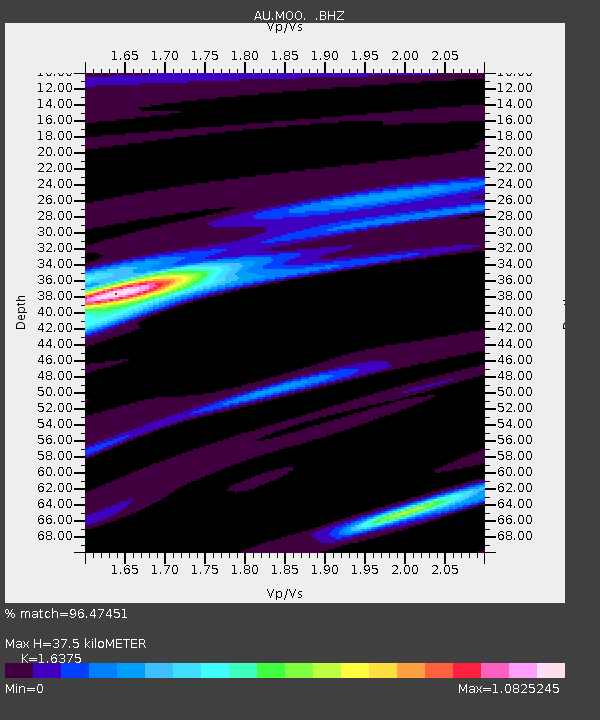
MOO Moorlands, Tasmania - Earthquake Result Viewer

Earthquake location: Irian Jaya Region, Indonesia
Earthquake latitude/longitude: -0.7/133.3
Earthquake time(UTC): 2009/01/03 (003) 22:33:40 GMT
Earthquake Depth: 23 km
Earthquake Magnitude: 6.7 MB, 7.4 MS, 7.4 MW, 7.3 MW
Earthquake Catalog/Contributor: WHDF/NEIC
Network: AU Australian Seismological Centre
Station: MOO Moorlands, Tasmania
Lat/Lon: 42.44 S/147.19 E
Elevation: 325 m
Distance: 43.4 deg
Az: 165.016 deg
Baz: 339.558 deg
Ray Param: 0.07254144
Estimated Moho Depth: 37.5 km
Estimated Crust Vp/Vs: 1.64
Assumed Crust Vp: 6.477 km/s
Estimated Crust Vs: 3.955 km/s
Estimated Crust Poisson's Ratio: 0.20
Radial Match: 96.47451 %
Radial Bump: 347
Transverse Match: 81.50927 %
Transverse Bump: 400
SOD ConfigId: 2834
Insert Time: 2010-03-09 00:12:08.516 +0000
GWidth: 2.5
Max Bumps: 400
Tol: 0.001

Signal To Noise

ChannelStoNSTALTA
AU:MOO: :BHZ:20090103T22:41:10.24401Z8.5350061.0974119E-51.2857776E-6
AU:MOO: :BHN:20090103T22:41:10.24401Z11.1289346.302708E-65.663353E-7
AU:MOO: :BHE:20090103T22:41:10.24401Z4.6578342.1501987E-64.6163058E-7
Arrivals
Ps4.0 SECOND
PpPs14 SECOND
PsPs/PpSs18 SECOND