You are here: Home > Network List > TA - USArray Transportable Network (new EarthScope stations) Stations List
> Station M29M Somme Creek, YT, CAN > Earthquake Result Viewer
M29M Somme Creek, YT, CAN - Earthquake Result Viewer
| Earthquake location: |
Samar, Philippines |
| Earthquake latitude/longitude: |
12.0/124.1 |
| Earthquake time(UTC): |
2020/08/18 (231) 00:03:48 GMT |
| Earthquake Depth: |
10 km |
| Earthquake Magnitude: |
6.7 mww |
| Earthquake Catalog/Contributor: |
NEIC PDE/us |
|
| Network: |
TA USArray Transportable Network (new EarthScope stations) |
| Station: |
M29M Somme Creek, YT, CAN |
| Lat/Lon: |
62.44 N/138.46 W |
| Elevation: |
1297 m |
|
| Distance: |
82.9 deg |
| Az: |
27.695 deg |
| Baz: |
282.11 deg |
| Ray Param: |
0.04659498 |
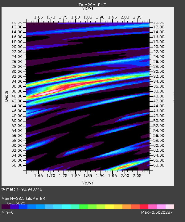
| Estimated Moho Depth: |
38.5 km |
| Estimated Crust Vp/Vs: |
1.68 |
| Assumed Crust Vp: |
6.566 km/s |
| Estimated Crust Vs: |
3.903 km/s |
| Estimated Crust Poisson's Ratio: |
0.23 |
|
| Radial Match: |
93.948746 % |
| Radial Bump: |
367 |
| Transverse Match: |
88.06958 % |
| Transverse Bump: |
362 |
| SOD ConfigId: |
21709731 |
| Insert Time: |
2020-09-01 00:17:31.067 +0000 |
| GWidth: |
2.5 |
| Max Bumps: |
400 |
| Tol: |
0.001 |
|

Signal To Noise
| Channel | StoN | STA | LTA |
| TA:M29M: :BHZ:20200818T00:15:42.050015Z | 5.616185 | 2.8741377E-7 | 5.1175977E-8 |
| TA:M29M: :BHN:20200818T00:15:42.050015Z | 0.5233387 | 4.2299916E-8 | 8.082704E-8 |
| TA:M29M: :BHE:20200818T00:15:42.050015Z | 3.1546395 | 1.2238671E-7 | 3.8795783E-8 |
| Arrivals |
| Ps | 4.1 SECOND |
| PpPs | 15 SECOND |
| PsPs/PpSs | 19 SECOND |


