You are here: Home > Network List > TA - USArray Transportable Network (new EarthScope stations) Stations List
> Station N16K Nishlik Lake, AK, USA > Earthquake Result Viewer
N16K Nishlik Lake, AK, USA - Earthquake Result Viewer
| Earthquake location: |
Samar, Philippines |
| Earthquake latitude/longitude: |
12.0/124.1 |
| Earthquake time(UTC): |
2020/08/18 (231) 00:03:48 GMT |
| Earthquake Depth: |
10 km |
| Earthquake Magnitude: |
6.7 mww |
| Earthquake Catalog/Contributor: |
NEIC PDE/us |
|
| Network: |
TA USArray Transportable Network (new EarthScope stations) |
| Station: |
N16K Nishlik Lake, AK, USA |
| Lat/Lon: |
60.47 N/158.77 W |
| Elevation: |
582 m |
|
| Distance: |
73.3 deg |
| Az: |
30.276 deg |
| Baz: |
264.789 deg |
| Ray Param: |
0.05310544 |
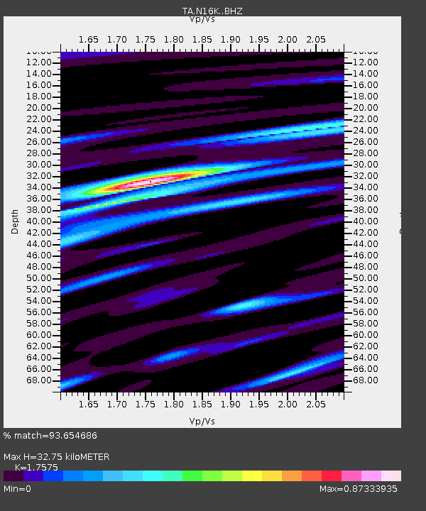
| Estimated Moho Depth: |
32.75 km |
| Estimated Crust Vp/Vs: |
1.76 |
| Assumed Crust Vp: |
6.276 km/s |
| Estimated Crust Vs: |
3.571 km/s |
| Estimated Crust Poisson's Ratio: |
0.26 |
|
| Radial Match: |
93.654686 % |
| Radial Bump: |
307 |
| Transverse Match: |
92.59817 % |
| Transverse Bump: |
400 |
| SOD ConfigId: |
21709731 |
| Insert Time: |
2020-09-01 00:17:36.242 +0000 |
| GWidth: |
2.5 |
| Max Bumps: |
400 |
| Tol: |
0.001 |
|

Signal To Noise
| Channel | StoN | STA | LTA |
| TA:N16K: :BHZ:20200818T00:14:49.074979Z | 7.4265943 | 3.520427E-7 | 4.7402978E-8 |
| TA:N16K: :BHN:20200818T00:14:49.074979Z | 1.3852262 | 4.7131692E-8 | 3.4024545E-8 |
| TA:N16K: :BHE:20200818T00:14:49.074979Z | 4.051285 | 1.7573922E-7 | 4.337864E-8 |
| Arrivals |
| Ps | 4.1 SECOND |
| PpPs | 14 SECOND |
| PsPs/PpSs | 18 SECOND |


