You are here: Home > Network List > AU - Australian Seismological Centre Stations List
> Station MOO Moorlands, Tasmania > Earthquake Result Viewer
MOO Moorlands, Tasmania - Earthquake Result Viewer
| Earthquake location: |
East Of Kuril Islands |
| Earthquake latitude/longitude: |
46.9/155.2 |
| Earthquake time(UTC): |
2009/01/15 (015) 17:49:39 GMT |
| Earthquake Depth: |
36 km |
| Earthquake Magnitude: |
6.9 MB, 7.5 MS, 7.4 MW, 7.4 MW |
| Earthquake Catalog/Contributor: |
WHDF/NEIC |
|
| Network: |
AU Australian Seismological Centre |
| Station: |
MOO Moorlands, Tasmania |
| Lat/Lon: |
42.44 S/147.19 E |
| Elevation: |
325 m |
|
| Distance: |
89.2 deg |
| Az: |
185.887 deg |
| Baz: |
5.456 deg |
| Ray Param: |
0.041979615 |
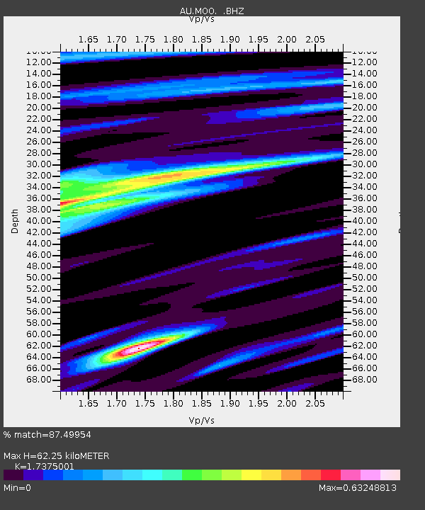
| Estimated Moho Depth: |
62.25 km |
| Estimated Crust Vp/Vs: |
1.74 |
| Assumed Crust Vp: |
6.477 km/s |
| Estimated Crust Vs: |
3.728 km/s |
| Estimated Crust Poisson's Ratio: |
0.25 |
|
| Radial Match: |
87.49954 % |
| Radial Bump: |
362 |
| Transverse Match: |
71.700836 % |
| Transverse Bump: |
400 |
| SOD ConfigId: |
2834 |
| Insert Time: |
2010-03-09 00:12:10.880 +0000 |
| GWidth: |
2.5 |
| Max Bumps: |
400 |
| Tol: |
0.001 |
|

Signal To Noise
| Channel | StoN | STA | LTA |
| AU:MOO: :BHZ:20090115T18:01:59.845024Z | 7.5428185 | 1.0082717E-5 | 1.3367306E-6 |
| AU:MOO: :BHN:20090115T18:01:59.845024Z | 5.7210007 | 3.879661E-6 | 6.781438E-7 |
| AU:MOO: :BHE:20090115T18:01:59.845024Z | 0.9747631 | 1.0706647E-6 | 1.0983846E-6 |
| Arrivals |
| Ps | 7.2 SECOND |
| PpPs | 26 SECOND |
| PsPs/PpSs | 33 SECOND |


