You are here: Home > Network List > TA - USArray Transportable Network (new EarthScope stations) Stations List
> Station O16K Kokwok River, Bristol Bay, AK, USA > Earthquake Result Viewer
O16K Kokwok River, Bristol Bay, AK, USA - Earthquake Result Viewer
| Earthquake location: |
Samar, Philippines |
| Earthquake latitude/longitude: |
12.0/124.1 |
| Earthquake time(UTC): |
2020/08/18 (231) 00:03:48 GMT |
| Earthquake Depth: |
10 km |
| Earthquake Magnitude: |
6.7 mww |
| Earthquake Catalog/Contributor: |
NEIC PDE/us |
|
| Network: |
TA USArray Transportable Network (new EarthScope stations) |
| Station: |
O16K Kokwok River, Bristol Bay, AK, USA |
| Lat/Lon: |
59.59 N/158.09 W |
| Elevation: |
198 m |
|
| Distance: |
73.6 deg |
| Az: |
31.224 deg |
| Baz: |
265.644 deg |
| Ray Param: |
0.05293177 |
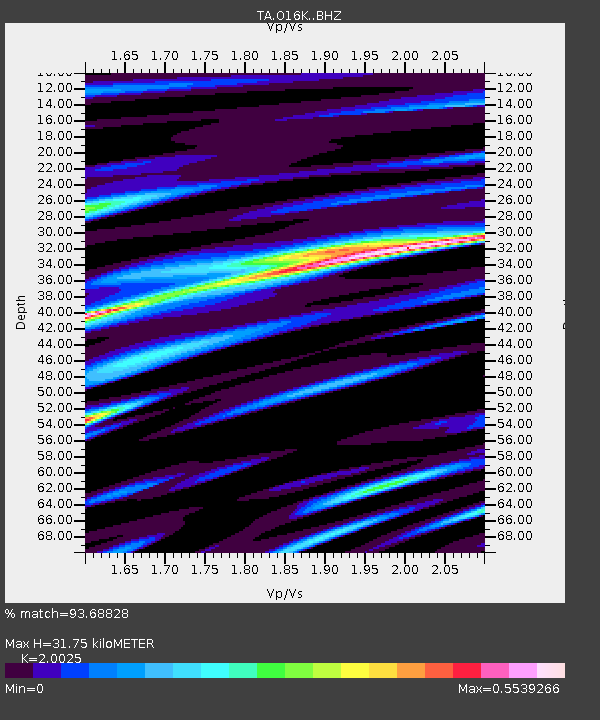
| Estimated Moho Depth: |
31.75 km |
| Estimated Crust Vp/Vs: |
2.00 |
| Assumed Crust Vp: |
6.24 km/s |
| Estimated Crust Vs: |
3.116 km/s |
| Estimated Crust Poisson's Ratio: |
0.33 |
|
| Radial Match: |
93.68828 % |
| Radial Bump: |
323 |
| Transverse Match: |
91.36941 % |
| Transverse Bump: |
383 |
| SOD ConfigId: |
21709731 |
| Insert Time: |
2020-09-01 00:17:46.460 +0000 |
| GWidth: |
2.5 |
| Max Bumps: |
400 |
| Tol: |
0.001 |
|

Signal To Noise
| Channel | StoN | STA | LTA |
| TA:O16K: :BHZ:20200818T00:14:50.625027Z | 12.083778 | 4.69872E-7 | 3.8884526E-8 |
| TA:O16K: :BHN:20200818T00:14:50.625027Z | 1.2851104 | 4.7888218E-8 | 3.7263895E-8 |
| TA:O16K: :BHE:20200818T00:14:50.625027Z | 6.3648596 | 1.8006486E-7 | 2.8290467E-8 |
| Arrivals |
| Ps | 5.2 SECOND |
| PpPs | 15 SECOND |
| PsPs/PpSs | 20 SECOND |


