You are here: Home > Network List > TA - USArray Transportable Network (new EarthScope stations) Stations List
> Station O28M Mount Upton, YT, CAN > Earthquake Result Viewer
O28M Mount Upton, YT, CAN - Earthquake Result Viewer
| Earthquake location: |
Samar, Philippines |
| Earthquake latitude/longitude: |
12.0/124.1 |
| Earthquake time(UTC): |
2020/08/18 (231) 00:03:48 GMT |
| Earthquake Depth: |
10 km |
| Earthquake Magnitude: |
6.7 mww |
| Earthquake Catalog/Contributor: |
NEIC PDE/us |
|
| Network: |
TA USArray Transportable Network (new EarthScope stations) |
| Station: |
O28M Mount Upton, YT, CAN |
| Lat/Lon: |
60.77 N/140.19 W |
| Elevation: |
2622 m |
|
| Distance: |
82.4 deg |
| Az: |
29.518 deg |
| Baz: |
280.826 deg |
| Ray Param: |
0.046922836 |
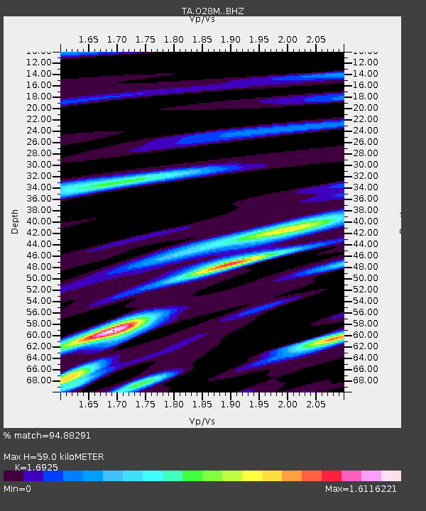
| Estimated Moho Depth: |
59.0 km |
| Estimated Crust Vp/Vs: |
1.69 |
| Assumed Crust Vp: |
6.566 km/s |
| Estimated Crust Vs: |
3.88 km/s |
| Estimated Crust Poisson's Ratio: |
0.23 |
|
| Radial Match: |
94.88291 % |
| Radial Bump: |
336 |
| Transverse Match: |
91.73528 % |
| Transverse Bump: |
366 |
| SOD ConfigId: |
21709731 |
| Insert Time: |
2020-09-01 00:17:49.435 +0000 |
| GWidth: |
2.5 |
| Max Bumps: |
400 |
| Tol: |
0.001 |
|

Signal To Noise
| Channel | StoN | STA | LTA |
| TA:O28M: :BHZ:20200818T00:15:39.574979Z | 4.283424 | 2.3797153E-7 | 5.555638E-8 |
| TA:O28M: :BHN:20200818T00:15:39.574979Z | 0.42472687 | 2.62456E-8 | 6.179406E-8 |
| TA:O28M: :BHE:20200818T00:15:39.574979Z | 2.2817888 | 1.0056128E-7 | 4.4071246E-8 |
| Arrivals |
| Ps | 6.4 SECOND |
| PpPs | 24 SECOND |
| PsPs/PpSs | 30 SECOND |


