You are here: Home > Network List > TA - USArray Transportable Network (new EarthScope stations) Stations List
> Station R33M Jennings River, BC, CAN > Earthquake Result Viewer
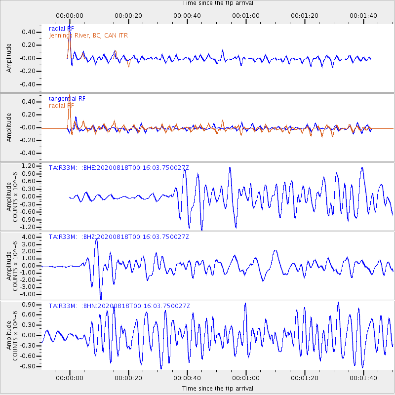
R33M Jennings River, BC, CAN - Earthquake Result Viewer
*The percent match for this event was below the threshold and hence no stack was calculated.
| Earthquake location: |
Samar, Philippines |
| Earthquake latitude/longitude: |
12.0/124.1 |
| Earthquake time(UTC): |
2020/08/18 (231) 00:03:48 GMT |
| Earthquake Depth: |
10 km |
| Earthquake Magnitude: |
6.7 mww |
| Earthquake Catalog/Contributor: |
NEIC PDE/us |
|
| Network: |
TA USArray Transportable Network (new EarthScope stations) |
| Station: |
R33M Jennings River, BC, CAN |
| Lat/Lon: |
59.39 N/130.97 W |
| Elevation: |
1437 m |
|
| Distance: |
87.2 deg |
| Az: |
29.669 deg |
| Baz: |
288.826 deg |
| Ray Param: |
$rayparam |
*The percent match for this event was below the threshold and hence was not used in the summary stack. |
|
| Radial Match: |
79.51104 % |
| Radial Bump: |
301 |
| Transverse Match: |
79.44664 % |
| Transverse Bump: |
395 |
| SOD ConfigId: |
21709731 |
| Insert Time: |
2020-09-01 00:18:00.738 +0000 |
| GWidth: |
2.5 |
| Max Bumps: |
400 |
| Tol: |
0.001 |
|
Signal To Noise
| Channel | StoN | STA | LTA |
| TA:R33M: :BHZ:20200818T00:16:03.750027Z | 2.6357396 | 1.69145E-7 | 6.417364E-8 |
| TA:R33M: :BHN:20200818T00:16:03.750027Z | 0.7346071 | 5.42485E-8 | 7.384696E-8 |
| TA:R33M: :BHE:20200818T00:16:03.750027Z | 1.123087 | 8.184578E-8 | 7.287572E-8 |
| Arrivals |
| Ps | |
| PpPs | |
| PsPs/PpSs | |


