You are here: Home > Network List > AV - Alaska Volcano Observatory Stations List
> Station ETKA Kagalaska Island, Regional Station, Alaska > Earthquake Result Viewer
ETKA Kagalaska Island, Regional Station, Alaska - Earthquake Result Viewer
| Earthquake location: |
Southern Sumatra, Indonesia |
| Earthquake latitude/longitude: |
-4.4/101.1 |
| Earthquake time(UTC): |
2020/08/18 (231) 22:23:57 GMT |
| Earthquake Depth: |
10 km |
| Earthquake Magnitude: |
6.8 mww |
| Earthquake Catalog/Contributor: |
NEIC PDE/us |
|
| Network: |
AV Alaska Volcano Observatory |
| Station: |
ETKA Kagalaska Island, Regional Station, Alaska |
| Lat/Lon: |
51.86 N/176.41 W |
| Elevation: |
290 m |
|
| Distance: |
88.8 deg |
| Az: |
37.95 deg |
| Baz: |
261.423 deg |
| Ray Param: |
0.04233384 |
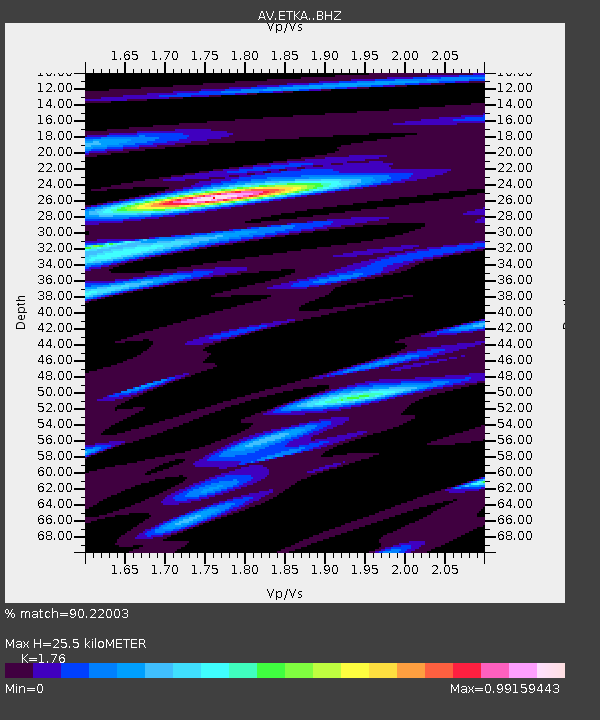
| Estimated Moho Depth: |
25.5 km |
| Estimated Crust Vp/Vs: |
1.76 |
| Assumed Crust Vp: |
5.88 km/s |
| Estimated Crust Vs: |
3.341 km/s |
| Estimated Crust Poisson's Ratio: |
0.26 |
|
| Radial Match: |
90.22003 % |
| Radial Bump: |
378 |
| Transverse Match: |
76.11288 % |
| Transverse Bump: |
400 |
| SOD ConfigId: |
21709731 |
| Insert Time: |
2020-09-01 22:27:55.336 +0000 |
| GWidth: |
2.5 |
| Max Bumps: |
400 |
| Tol: |
0.001 |
|

Signal To Noise
| Channel | StoN | STA | LTA |
| AV:ETKA: :BHZ:20200818T22:36:19.679999Z | 14.376498 | 2.1573185E-6 | 1.5005868E-7 |
| AV:ETKA: :BHN:20200818T22:36:19.679999Z | 1.1519433 | 2.679578E-7 | 2.326137E-7 |
| AV:ETKA: :BHE:20200818T22:36:19.679999Z | 5.869671 | 7.6056364E-7 | 1.2957517E-7 |
| Arrivals |
| Ps | 3.4 SECOND |
| PpPs | 12 SECOND |
| PsPs/PpSs | 15 SECOND |


