You are here: Home > Network List > AV - Alaska Volcano Observatory Stations List
> Station GSIG Igitkin Island, Great Sitkin Volcano, Alaska > Earthquake Result Viewer
GSIG Igitkin Island, Great Sitkin Volcano, Alaska - Earthquake Result Viewer
| Earthquake location: |
Southern Sumatra, Indonesia |
| Earthquake latitude/longitude: |
-4.4/101.1 |
| Earthquake time(UTC): |
2020/08/18 (231) 22:23:57 GMT |
| Earthquake Depth: |
10 km |
| Earthquake Magnitude: |
6.8 mww |
| Earthquake Catalog/Contributor: |
NEIC PDE/us |
|
| Network: |
AV Alaska Volcano Observatory |
| Station: |
GSIG Igitkin Island, Great Sitkin Volcano, Alaska |
| Lat/Lon: |
51.99 N/175.93 W |
| Elevation: |
407 m |
|
| Distance: |
89.1 deg |
| Az: |
37.87 deg |
| Baz: |
261.799 deg |
| Ray Param: |
0.0421099 |
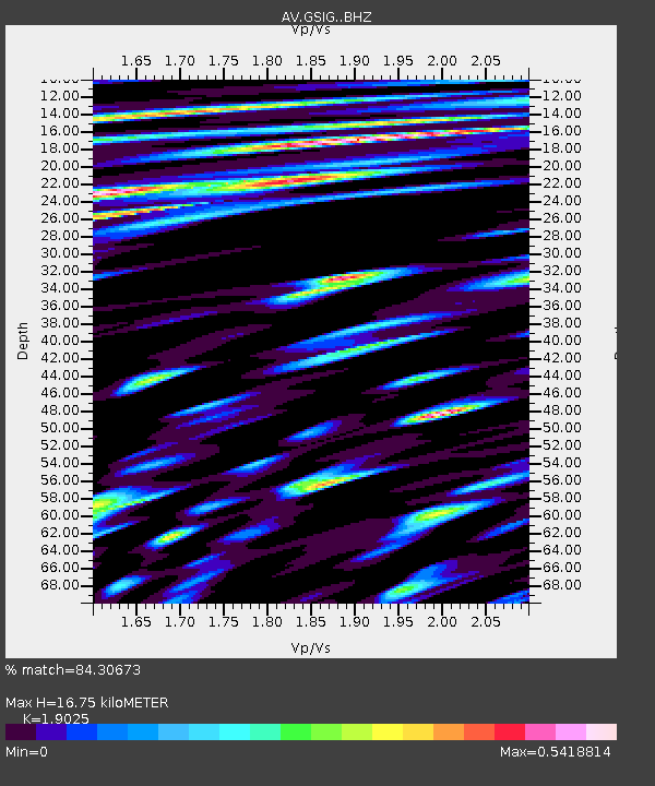
| Estimated Moho Depth: |
16.75 km |
| Estimated Crust Vp/Vs: |
1.90 |
| Assumed Crust Vp: |
3.943 km/s |
| Estimated Crust Vs: |
2.073 km/s |
| Estimated Crust Poisson's Ratio: |
0.31 |
|
| Radial Match: |
84.30673 % |
| Radial Bump: |
400 |
| Transverse Match: |
72.8712 % |
| Transverse Bump: |
400 |
| SOD ConfigId: |
21709731 |
| Insert Time: |
2020-09-01 22:28:06.425 +0000 |
| GWidth: |
2.5 |
| Max Bumps: |
400 |
| Tol: |
0.001 |
|

Signal To Noise
| Channel | StoN | STA | LTA |
| AV:GSIG: :BHZ:20200818T22:36:21.140021Z | 12.785872 | 2.290001E-6 | 1.79104E-7 |
| AV:GSIG: :BHN:20200818T22:36:21.140021Z | 0.72015357 | 1.6852866E-7 | 2.3401768E-7 |
| AV:GSIG: :BHE:20200818T22:36:21.140021Z | 2.5904825 | 6.682669E-7 | 2.5797004E-7 |
| Arrivals |
| Ps | 3.9 SECOND |
| PpPs | 12 SECOND |
| PsPs/PpSs | 16 SECOND |


