You are here: Home > Network List > AV - Alaska Volcano Observatory Stations List
> Station GSMY Middle Yoke Creek, Great Sitkin Volcano, Alaska > Earthquake Result Viewer
GSMY Middle Yoke Creek, Great Sitkin Volcano, Alaska - Earthquake Result Viewer
| Earthquake location: |
Southern Sumatra, Indonesia |
| Earthquake latitude/longitude: |
-4.4/101.1 |
| Earthquake time(UTC): |
2020/08/18 (231) 22:23:57 GMT |
| Earthquake Depth: |
10 km |
| Earthquake Magnitude: |
6.8 mww |
| Earthquake Catalog/Contributor: |
NEIC PDE/us |
|
| Network: |
AV Alaska Volcano Observatory |
| Station: |
GSMY Middle Yoke Creek, Great Sitkin Volcano, Alaska |
| Lat/Lon: |
52.04 N/176.06 W |
| Elevation: |
418 m |
|
| Distance: |
89.0 deg |
| Az: |
37.802 deg |
| Baz: |
261.694 deg |
| Ray Param: |
0.042162254 |
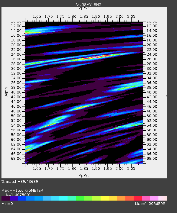
| Estimated Moho Depth: |
15.0 km |
| Estimated Crust Vp/Vs: |
1.61 |
| Assumed Crust Vp: |
3.912 km/s |
| Estimated Crust Vs: |
2.433 km/s |
| Estimated Crust Poisson's Ratio: |
0.18 |
|
| Radial Match: |
89.43639 % |
| Radial Bump: |
400 |
| Transverse Match: |
81.449234 % |
| Transverse Bump: |
400 |
| SOD ConfigId: |
21709731 |
| Insert Time: |
2020-09-01 22:28:09.176 +0000 |
| GWidth: |
2.5 |
| Max Bumps: |
400 |
| Tol: |
0.001 |
|

Signal To Noise
| Channel | StoN | STA | LTA |
| AV:GSMY: :BHZ:20200818T22:36:20.799017Z | 14.755375 | 2.1736034E-6 | 1.4730927E-7 |
| AV:GSMY: :BHN:20200818T22:36:20.799017Z | 1.4053317 | 4.2656484E-7 | 3.035332E-7 |
| AV:GSMY: :BHE:20200818T22:36:20.799017Z | 3.47928 | 8.821188E-7 | 2.5353486E-7 |
| Arrivals |
| Ps | 2.3 SECOND |
| PpPs | 9.9 SECOND |
| PsPs/PpSs | 12 SECOND |


