You are here: Home > Network List > AV - Alaska Volcano Observatory Stations List
> Station TASE Southeast, Tanaga Volcano, Alaska > Earthquake Result Viewer
TASE Southeast, Tanaga Volcano, Alaska - Earthquake Result Viewer
| Earthquake location: |
Southern Sumatra, Indonesia |
| Earthquake latitude/longitude: |
-4.4/101.1 |
| Earthquake time(UTC): |
2020/08/18 (231) 22:23:57 GMT |
| Earthquake Depth: |
10 km |
| Earthquake Magnitude: |
6.8 mww |
| Earthquake Catalog/Contributor: |
NEIC PDE/us |
|
| Network: |
AV Alaska Volcano Observatory |
| Station: |
TASE Southeast, Tanaga Volcano, Alaska |
| Lat/Lon: |
51.83 N/178.04 W |
| Elevation: |
682 m |
|
| Distance: |
87.8 deg |
| Az: |
37.814 deg |
| Baz: |
260.139 deg |
| Ray Param: |
0.043081798 |
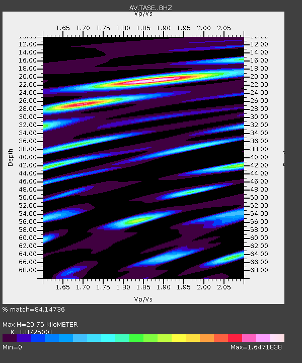
| Estimated Moho Depth: |
20.75 km |
| Estimated Crust Vp/Vs: |
1.87 |
| Assumed Crust Vp: |
6.048 km/s |
| Estimated Crust Vs: |
3.23 km/s |
| Estimated Crust Poisson's Ratio: |
0.30 |
|
| Radial Match: |
84.14736 % |
| Radial Bump: |
400 |
| Transverse Match: |
84.00581 % |
| Transverse Bump: |
400 |
| SOD ConfigId: |
21709731 |
| Insert Time: |
2020-09-01 22:28:48.037 +0000 |
| GWidth: |
2.5 |
| Max Bumps: |
400 |
| Tol: |
0.001 |
|

Signal To Noise
| Channel | StoN | STA | LTA |
| AV:TASE: :BHZ:20200818T22:36:14.919012Z | 10.43456 | 2.1802964E-6 | 2.0894954E-7 |
| AV:TASE: :BHN:20200818T22:36:14.919012Z | 1.8838376 | 5.185824E-7 | 2.7527977E-7 |
| AV:TASE: :BHE:20200818T22:36:14.919012Z | 3.0949836 | 8.659523E-7 | 2.797922E-7 |
| Arrivals |
| Ps | 3.0 SECOND |
| PpPs | 9.7 SECOND |
| PsPs/PpSs | 13 SECOND |


