You are here: Home > Network List > CH - Switzerland Seismological Network Stations List
> Station BRANT Les Verrieres > Earthquake Result Viewer
BRANT Les Verrieres - Earthquake Result Viewer
| Earthquake location: |
Southern Sumatra, Indonesia |
| Earthquake latitude/longitude: |
-4.4/101.1 |
| Earthquake time(UTC): |
2020/08/18 (231) 22:23:57 GMT |
| Earthquake Depth: |
10 km |
| Earthquake Magnitude: |
6.8 mww |
| Earthquake Catalog/Contributor: |
NEIC PDE/us |
|
| Network: |
CH Switzerland Seismological Network |
| Station: |
BRANT Les Verrieres |
| Lat/Lon: |
46.94 N/6.47 E |
| Elevation: |
1145 m |
|
| Distance: |
96.3 deg |
| Az: |
316.592 deg |
| Baz: |
89.618 deg |
| Ray Param: |
0.04054779 |
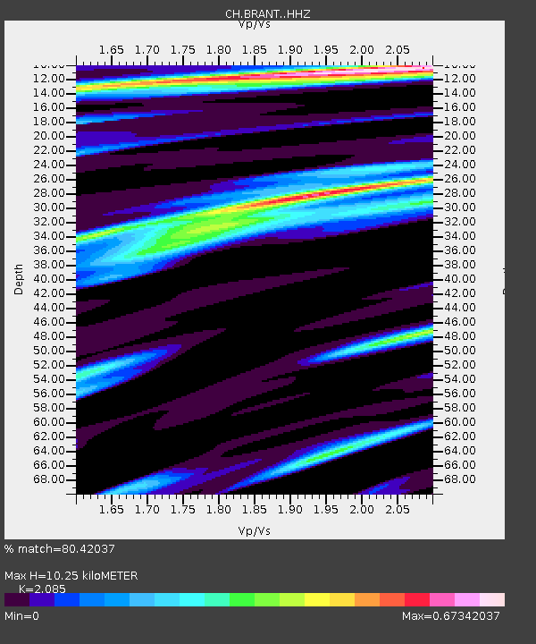
| Estimated Moho Depth: |
10.25 km |
| Estimated Crust Vp/Vs: |
2.09 |
| Assumed Crust Vp: |
6.276 km/s |
| Estimated Crust Vs: |
3.01 km/s |
| Estimated Crust Poisson's Ratio: |
0.35 |
|
| Radial Match: |
80.42037 % |
| Radial Bump: |
400 |
| Transverse Match: |
66.826065 % |
| Transverse Bump: |
400 |
| SOD ConfigId: |
21709731 |
| Insert Time: |
2020-09-01 22:29:08.741 +0000 |
| GWidth: |
2.5 |
| Max Bumps: |
400 |
| Tol: |
0.001 |
|

Signal To Noise
| Channel | StoN | STA | LTA |
| CH:BRANT: :HHZ:20200818T22:36:54.335028Z | 3.8240278 | 1.098858E-6 | 2.8735616E-7 |
| CH:BRANT: :HHN:20200818T22:36:54.335028Z | 1.1932567 | 2.5354825E-7 | 2.1248424E-7 |
| CH:BRANT: :HHE:20200818T22:36:54.335028Z | 1.074211 | 2.5578427E-7 | 2.3811361E-7 |
| Arrivals |
| Ps | 1.8 SECOND |
| PpPs | 5.0 SECOND |
| PsPs/PpSs | 6.8 SECOND |


