You are here: Home > Network List > IU - Global Seismograph Network (GSN - IRIS/USGS) Stations List
> Station MA2 Magadan, Russia > Earthquake Result Viewer
MA2 Magadan, Russia - Earthquake Result Viewer
| Earthquake location: |
Southern Sumatra, Indonesia |
| Earthquake latitude/longitude: |
-4.4/101.1 |
| Earthquake time(UTC): |
2020/08/18 (231) 22:23:57 GMT |
| Earthquake Depth: |
10 km |
| Earthquake Magnitude: |
6.8 mww |
| Earthquake Catalog/Contributor: |
NEIC PDE/us |
|
| Network: |
IU Global Seismograph Network (GSN - IRIS/USGS) |
| Station: |
MA2 Magadan, Russia |
| Lat/Lon: |
59.58 N/150.77 E |
| Elevation: |
339 m |
|
| Distance: |
74.7 deg |
| Az: |
23.715 deg |
| Baz: |
231.997 deg |
| Ray Param: |
0.052136615 |
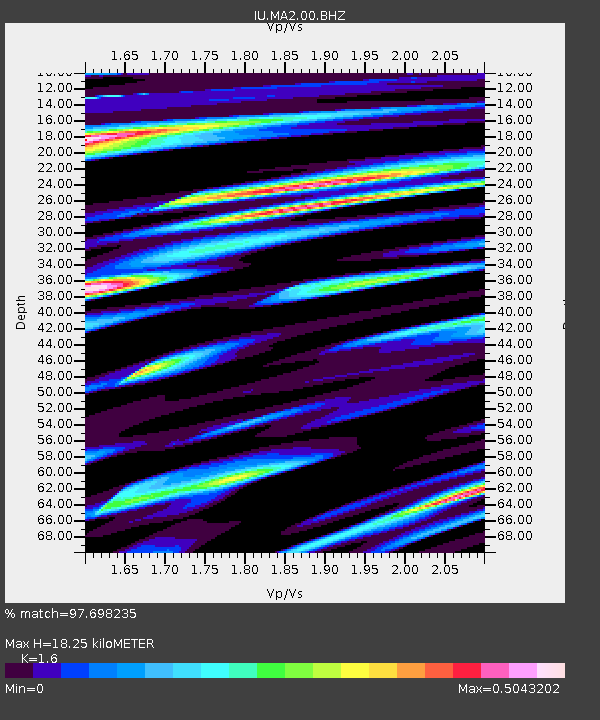
| Estimated Moho Depth: |
18.25 km |
| Estimated Crust Vp/Vs: |
1.60 |
| Assumed Crust Vp: |
6.134 km/s |
| Estimated Crust Vs: |
3.834 km/s |
| Estimated Crust Poisson's Ratio: |
0.18 |
|
| Radial Match: |
97.698235 % |
| Radial Bump: |
336 |
| Transverse Match: |
91.93328 % |
| Transverse Bump: |
400 |
| SOD ConfigId: |
21709731 |
| Insert Time: |
2020-09-01 22:30:51.178 +0000 |
| GWidth: |
2.5 |
| Max Bumps: |
400 |
| Tol: |
0.001 |
|
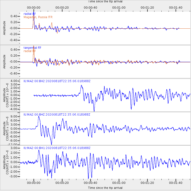
Signal To Noise
| Channel | StoN | STA | LTA |
| IU:MA2:00:BHZ:20200818T22:35:06.018988Z | 33.52847 | 4.2280785E-6 | 1.2610413E-7 |
| IU:MA2:00:BH1:20200818T22:35:06.018988Z | 7.729875 | 1.0707937E-6 | 1.3852666E-7 |
| IU:MA2:00:BH2:20200818T22:35:06.018988Z | 12.914751 | 1.3911049E-6 | 1.0771442E-7 |
| Arrivals |
| Ps | 1.8 SECOND |
| PpPs | 7.5 SECOND |
| PsPs/PpSs | 9.3 SECOND |


