You are here: Home > Network List > JP - Japan Meteorological Agency Seismic Network Stations List
> Station JMN Kochi Monobe > Earthquake Result Viewer
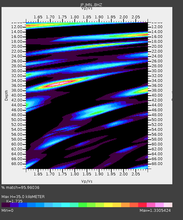
JMN Kochi Monobe - Earthquake Result Viewer
| Earthquake location: |
Southern Sumatra, Indonesia |
| Earthquake latitude/longitude: |
-4.4/101.1 |
| Earthquake time(UTC): |
2020/08/18 (231) 22:23:57 GMT |
| Earthquake Depth: |
10 km |
| Earthquake Magnitude: |
6.8 mww |
| Earthquake Catalog/Contributor: |
NEIC PDE/us |
|
| Network: |
JP Japan Meteorological Agency Seismic Network |
| Station: |
JMN Kochi Monobe |
| Lat/Lon: |
33.73 N/133.88 E |
| Elevation: |
550 m |
|
| Distance: |
48.9 deg |
| Az: |
36.752 deg |
| Baz: |
225.72 deg |
| Ray Param: |
0.0690286 |
| Estimated Moho Depth: |
35.0 km |
| Estimated Crust Vp/Vs: |
1.74 |
| Assumed Crust Vp: |
6.468 km/s |
| Estimated Crust Vs: |
3.728 km/s |
| Estimated Crust Poisson's Ratio: |
0.25 |
|
| Radial Match: |
95.96036 % |
| Radial Bump: |
400 |
| Transverse Match: |
90.74123 % |
| Transverse Bump: |
400 |
| SOD ConfigId: |
21709731 |
| Insert Time: |
2020-09-01 22:31:10.393 +0000 |
| GWidth: |
2.5 |
| Max Bumps: |
400 |
| Tol: |
0.001 |
|

Signal To Noise
| Channel | StoN | STA | LTA |
| JP:JMN: :BHZ:20200818T22:32:12.699988Z | 69.8813 | 5.403347E-6 | 7.7321786E-8 |
| JP:JMN: :BHN:20200818T22:32:12.699988Z | 18.289078 | 1.4855755E-6 | 8.122747E-8 |
| JP:JMN: :BHE:20200818T22:32:12.699988Z | 39.967426 | 2.292099E-6 | 5.734918E-8 |
| Arrivals |
| Ps | 4.2 SECOND |
| PpPs | 14 SECOND |
| PsPs/PpSs | 18 SECOND |


