You are here: Home > Network List > TA - USArray Transportable Network (new EarthScope stations) Stations List
> Station B18K Kokolik River, AK, USA > Earthquake Result Viewer
B18K Kokolik River, AK, USA - Earthquake Result Viewer
| Earthquake location: |
Southern Sumatra, Indonesia |
| Earthquake latitude/longitude: |
-4.4/101.1 |
| Earthquake time(UTC): |
2020/08/18 (231) 22:23:57 GMT |
| Earthquake Depth: |
10 km |
| Earthquake Magnitude: |
6.8 mww |
| Earthquake Catalog/Contributor: |
NEIC PDE/us |
|
| Network: |
TA USArray Transportable Network (new EarthScope stations) |
| Station: |
B18K Kokolik River, AK, USA |
| Lat/Lon: |
69.36 N/161.80 W |
| Elevation: |
222 m |
|
| Distance: |
96.6 deg |
| Az: |
20.739 deg |
| Baz: |
275.108 deg |
| Ray Param: |
0.040476333 |
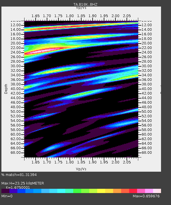
| Estimated Moho Depth: |
23.25 km |
| Estimated Crust Vp/Vs: |
1.68 |
| Assumed Crust Vp: |
5.906 km/s |
| Estimated Crust Vs: |
3.526 km/s |
| Estimated Crust Poisson's Ratio: |
0.22 |
|
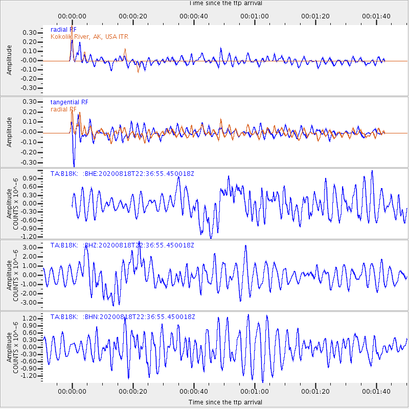
| Radial Match: |
81.31394 % |
| Radial Bump: |
400 |
| Transverse Match: |
75.468025 % |
| Transverse Bump: |
400 |
| SOD ConfigId: |
21709731 |
| Insert Time: |
2020-09-01 22:33:29.033 +0000 |
| GWidth: |
2.5 |
| Max Bumps: |
400 |
| Tol: |
0.001 |
|
Signal To Noise
| Channel | StoN | STA | LTA |
| TA:B18K: :BHZ:20200818T22:36:55.450018Z | 3.5118291 | 1.4492971E-6 | 4.126901E-7 |
| TA:B18K: :BHN:20200818T22:36:55.450018Z | 0.6897215 | 2.051477E-7 | 2.9743555E-7 |
| TA:B18K: :BHE:20200818T22:36:55.450018Z | 1.1620171 | 3.350982E-7 | 2.883763E-7 |
| Arrivals |
| Ps | 2.7 SECOND |
| PpPs | 10 SECOND |
| PsPs/PpSs | 13 SECOND |


