You are here: Home > Network List > TA - USArray Transportable Network (new EarthScope stations) Stations List
> Station L15K Ungalak Mountain, AK, USA > Earthquake Result Viewer
L15K Ungalak Mountain, AK, USA - Earthquake Result Viewer
| Earthquake location: |
Southern Sumatra, Indonesia |
| Earthquake latitude/longitude: |
-4.4/101.1 |
| Earthquake time(UTC): |
2020/08/18 (231) 22:23:57 GMT |
| Earthquake Depth: |
10 km |
| Earthquake Magnitude: |
6.8 mww |
| Earthquake Catalog/Contributor: |
NEIC PDE/us |
|
| Network: |
TA USArray Transportable Network (new EarthScope stations) |
| Station: |
L15K Ungalak Mountain, AK, USA |
| Lat/Lon: |
61.68 N/161.49 W |
| Elevation: |
219 m |
|
| Distance: |
97.4 deg |
| Az: |
28.478 deg |
| Baz: |
274.455 deg |
| Ray Param: |
0.04024427 |
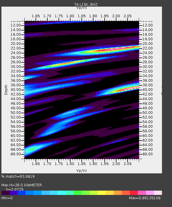
| Estimated Moho Depth: |
39.0 km |
| Estimated Crust Vp/Vs: |
2.07 |
| Assumed Crust Vp: |
6.182 km/s |
| Estimated Crust Vs: |
2.983 km/s |
| Estimated Crust Poisson's Ratio: |
0.35 |
|
| Radial Match: |
93.8619 % |
| Radial Bump: |
400 |
| Transverse Match: |
72.39356 % |
| Transverse Bump: |
400 |
| SOD ConfigId: |
21709731 |
| Insert Time: |
2020-09-01 22:34:07.120 +0000 |
| GWidth: |
2.5 |
| Max Bumps: |
400 |
| Tol: |
0.001 |
|

Signal To Noise
| Channel | StoN | STA | LTA |
| TA:L15K: :BHZ:20200818T22:36:58.924994Z | 11.99154 | 8.324621E-7 | 6.942078E-8 |
| TA:L15K: :BHN:20200818T22:36:58.924994Z | 0.9959216 | 5.9091843E-8 | 5.933383E-8 |
| TA:L15K: :BHE:20200818T22:36:58.924994Z | 5.6390057 | 2.9401298E-7 | 5.2139153E-8 |
| Arrivals |
| Ps | 6.9 SECOND |
| PpPs | 19 SECOND |
| PsPs/PpSs | 26 SECOND |


