You are here: Home > Network List > TA - USArray Transportable Network (new EarthScope stations) Stations List
> Station M11K Mekoryuk, AK, USA > Earthquake Result Viewer
M11K Mekoryuk, AK, USA - Earthquake Result Viewer
| Earthquake location: |
Southern Sumatra, Indonesia |
| Earthquake latitude/longitude: |
-4.4/101.1 |
| Earthquake time(UTC): |
2020/08/18 (231) 22:23:57 GMT |
| Earthquake Depth: |
10 km |
| Earthquake Magnitude: |
6.8 mww |
| Earthquake Catalog/Contributor: |
NEIC PDE/us |
|
| Network: |
TA USArray Transportable Network (new EarthScope stations) |
| Station: |
M11K Mekoryuk, AK, USA |
| Lat/Lon: |
60.38 N/166.20 W |
| Elevation: |
3.0 m |
|
| Distance: |
95.1 deg |
| Az: |
29.875 deg |
| Baz: |
270.185 deg |
| Ray Param: |
0.040878307 |
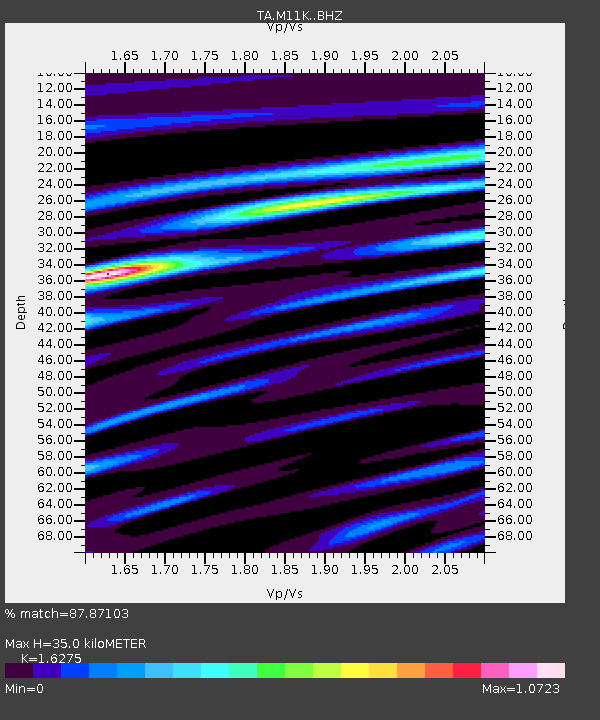
| Estimated Moho Depth: |
35.0 km |
| Estimated Crust Vp/Vs: |
1.63 |
| Assumed Crust Vp: |
6.134 km/s |
| Estimated Crust Vs: |
3.769 km/s |
| Estimated Crust Poisson's Ratio: |
0.20 |
|
| Radial Match: |
87.87103 % |
| Radial Bump: |
400 |
| Transverse Match: |
69.86649 % |
| Transverse Bump: |
400 |
| SOD ConfigId: |
21709731 |
| Insert Time: |
2020-09-01 22:34:09.834 +0000 |
| GWidth: |
2.5 |
| Max Bumps: |
400 |
| Tol: |
0.001 |
|

Signal To Noise
| Channel | StoN | STA | LTA |
| TA:M11K: :BHZ:20200818T22:36:48.849981Z | 6.084725 | 8.491265E-7 | 1.3955052E-7 |
| TA:M11K: :BHN:20200818T22:36:48.849981Z | 1.3698701 | 1.9431208E-7 | 1.4184708E-7 |
| TA:M11K: :BHE:20200818T22:36:48.849981Z | 1.7338117 | 2.3579646E-7 | 1.3599889E-7 |
| Arrivals |
| Ps | 3.7 SECOND |
| PpPs | 15 SECOND |
| PsPs/PpSs | 18 SECOND |


