You are here: Home > Network List > AK - Alaska Regional Network Stations List
> Station GAMB Gambell Broadband > Earthquake Result Viewer
GAMB Gambell Broadband - Earthquake Result Viewer
| Earthquake location: |
Southern Sumatra, Indonesia |
| Earthquake latitude/longitude: |
-4.3/101.2 |
| Earthquake time(UTC): |
2020/08/18 (231) 22:29:22 GMT |
| Earthquake Depth: |
10 km |
| Earthquake Magnitude: |
6.9 mww |
| Earthquake Catalog/Contributor: |
NEIC PDE/us |
|
| Network: |
AK Alaska Regional Network |
| Station: |
GAMB Gambell Broadband |
| Lat/Lon: |
63.78 N/171.70 W |
| Elevation: |
10 m |
|
| Distance: |
92.5 deg |
| Az: |
26.367 deg |
| Baz: |
265.5 deg |
| Ray Param: |
0.041445285 |
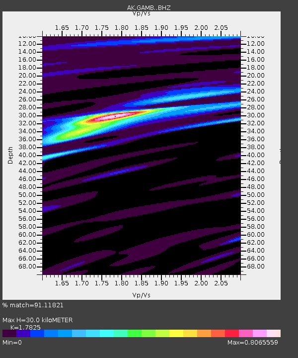
| Estimated Moho Depth: |
30.0 km |
| Estimated Crust Vp/Vs: |
1.78 |
| Assumed Crust Vp: |
6.24 km/s |
| Estimated Crust Vs: |
3.501 km/s |
| Estimated Crust Poisson's Ratio: |
0.27 |
|
| Radial Match: |
91.11821 % |
| Radial Bump: |
382 |
| Transverse Match: |
65.14453 % |
| Transverse Bump: |
400 |
| SOD ConfigId: |
21709731 |
| Insert Time: |
2020-09-01 22:35:20.783 +0000 |
| GWidth: |
2.5 |
| Max Bumps: |
400 |
| Tol: |
0.001 |
|
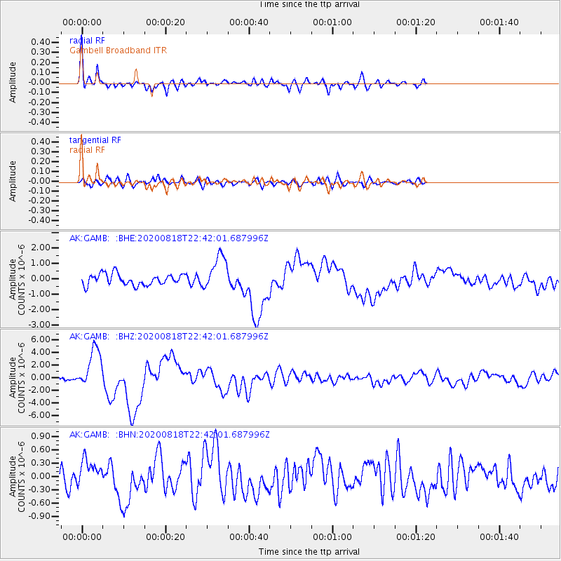
Signal To Noise
| Channel | StoN | STA | LTA |
| AK:GAMB: :BHZ:20200818T22:42:01.687996Z | 7.95417 | 3.3114043E-6 | 4.1631048E-7 |
| AK:GAMB: :BHN:20200818T22:42:01.687996Z | 1.0478437 | 2.686183E-7 | 2.5635342E-7 |
| AK:GAMB: :BHE:20200818T22:42:01.687996Z | 3.223438 | 1.1460388E-6 | 3.5553307E-7 |
| Arrivals |
| Ps | 3.8 SECOND |
| PpPs | 13 SECOND |
| PsPs/PpSs | 17 SECOND |


