You are here: Home > Network List > AV - Alaska Volcano Observatory Stations List
> Station ADAG Mount Adagdak, Regional Station, Alaska > Earthquake Result Viewer
ADAG Mount Adagdak, Regional Station, Alaska - Earthquake Result Viewer

| Earthquake location: |
Southern Sumatra, Indonesia |
| Earthquake latitude/longitude: |
-4.3/101.2 |
| Earthquake time(UTC): |
2020/08/18 (231) 22:29:22 GMT |
| Earthquake Depth: |
10 km |
| Earthquake Magnitude: |
6.9 mww |
| Earthquake Catalog/Contributor: |
NEIC PDE/us |
|
| Network: |
AV Alaska Volcano Observatory |
| Station: |
ADAG Mount Adagdak, Regional Station, Alaska |
| Lat/Lon: |
51.98 N/176.60 W |
| Elevation: |
281 m |
|
| Distance: |
88.5 deg |
| Az: |
37.803 deg |
| Baz: |
261.23 deg |
| Ray Param: |
0.042518493 |
| Estimated Moho Depth: |
14.25 km |
| Estimated Crust Vp/Vs: |
1.85 |
| Assumed Crust Vp: |
5.88 km/s |
| Estimated Crust Vs: |
3.179 km/s |
| Estimated Crust Poisson's Ratio: |
0.29 |
|
| Radial Match: |
81.7053 % |
| Radial Bump: |
400 |
| Transverse Match: |
75.694984 % |
| Transverse Bump: |
400 |
| SOD ConfigId: |
21709731 |
| Insert Time: |
2020-09-01 22:36:03.537 +0000 |
| GWidth: |
2.5 |
| Max Bumps: |
400 |
| Tol: |
0.001 |
|
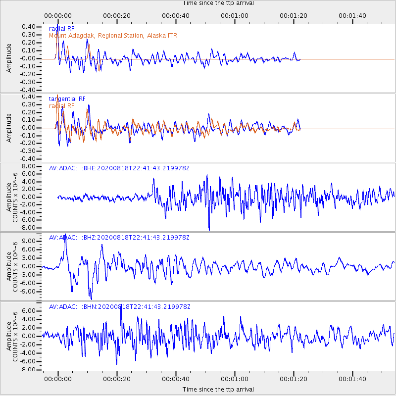
Signal To Noise
| Channel | StoN | STA | LTA |
| AV:ADAG: :BHZ:20200818T22:41:43.219978Z | 13.653657 | 4.7781373E-6 | 3.4995293E-7 |
| AV:ADAG: :BHN:20200818T22:41:43.219978Z | 2.6368687 | 1.2820109E-6 | 4.861869E-7 |
| AV:ADAG: :BHE:20200818T22:41:43.219978Z | 4.024328 | 1.6702083E-6 | 4.1502787E-7 |
| Arrivals |
| Ps | 2.1 SECOND |
| PpPs | 6.8 SECOND |
| PsPs/PpSs | 8.9 SECOND |


