You are here: Home > Network List > AV - Alaska Volcano Observatory Stations List
> Station GSIG Igitkin Island, Great Sitkin Volcano, Alaska > Earthquake Result Viewer
GSIG Igitkin Island, Great Sitkin Volcano, Alaska - Earthquake Result Viewer
| Earthquake location: |
Southern Sumatra, Indonesia |
| Earthquake latitude/longitude: |
-4.3/101.2 |
| Earthquake time(UTC): |
2020/08/18 (231) 22:29:22 GMT |
| Earthquake Depth: |
10 km |
| Earthquake Magnitude: |
6.9 mww |
| Earthquake Catalog/Contributor: |
NEIC PDE/us |
|
| Network: |
AV Alaska Volcano Observatory |
| Station: |
GSIG Igitkin Island, Great Sitkin Volcano, Alaska |
| Lat/Lon: |
51.99 N/175.93 W |
| Elevation: |
407 m |
|
| Distance: |
88.9 deg |
| Az: |
37.86 deg |
| Baz: |
261.761 deg |
| Ray Param: |
0.042215545 |
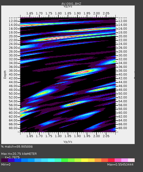
| Estimated Moho Depth: |
20.75 km |
| Estimated Crust Vp/Vs: |
1.79 |
| Assumed Crust Vp: |
3.943 km/s |
| Estimated Crust Vs: |
2.206 km/s |
| Estimated Crust Poisson's Ratio: |
0.27 |
|
| Radial Match: |
89.985886 % |
| Radial Bump: |
400 |
| Transverse Match: |
77.221725 % |
| Transverse Bump: |
400 |
| SOD ConfigId: |
21709731 |
| Insert Time: |
2020-09-01 22:36:32.487 +0000 |
| GWidth: |
2.5 |
| Max Bumps: |
400 |
| Tol: |
0.001 |
|

Signal To Noise
| Channel | StoN | STA | LTA |
| AV:GSIG: :BHZ:20200818T22:41:45.159004Z | 14.767363 | 4.2971446E-6 | 2.909893E-7 |
| AV:GSIG: :BHN:20200818T22:41:45.159004Z | 1.8055942 | 5.672718E-7 | 3.1417457E-7 |
| AV:GSIG: :BHE:20200818T22:41:45.159004Z | 3.857136 | 1.1852302E-6 | 3.0728245E-7 |
| Arrivals |
| Ps | 4.2 SECOND |
| PpPs | 15 SECOND |
| PsPs/PpSs | 19 SECOND |


