You are here: Home > Network List > AV - Alaska Volcano Observatory Stations List
> Station GSMY Middle Yoke Creek, Great Sitkin Volcano, Alaska > Earthquake Result Viewer
GSMY Middle Yoke Creek, Great Sitkin Volcano, Alaska - Earthquake Result Viewer
| Earthquake location: |
Southern Sumatra, Indonesia |
| Earthquake latitude/longitude: |
-4.3/101.2 |
| Earthquake time(UTC): |
2020/08/18 (231) 22:29:22 GMT |
| Earthquake Depth: |
10 km |
| Earthquake Magnitude: |
6.9 mww |
| Earthquake Catalog/Contributor: |
NEIC PDE/us |
|
| Network: |
AV Alaska Volcano Observatory |
| Station: |
GSMY Middle Yoke Creek, Great Sitkin Volcano, Alaska |
| Lat/Lon: |
52.04 N/176.06 W |
| Elevation: |
418 m |
|
| Distance: |
88.9 deg |
| Az: |
37.792 deg |
| Baz: |
261.657 deg |
| Ray Param: |
0.04226388 |
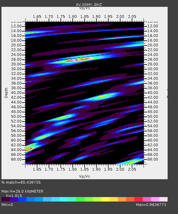
| Estimated Moho Depth: |
26.0 km |
| Estimated Crust Vp/Vs: |
1.82 |
| Assumed Crust Vp: |
3.912 km/s |
| Estimated Crust Vs: |
2.155 km/s |
| Estimated Crust Poisson's Ratio: |
0.28 |
|
| Radial Match: |
90.439735 % |
| Radial Bump: |
400 |
| Transverse Match: |
82.30757 % |
| Transverse Bump: |
400 |
| SOD ConfigId: |
21709731 |
| Insert Time: |
2020-09-01 22:36:34.502 +0000 |
| GWidth: |
2.5 |
| Max Bumps: |
400 |
| Tol: |
0.001 |
|

Signal To Noise
| Channel | StoN | STA | LTA |
| AV:GSMY: :BHZ:20200818T22:41:44.818977Z | 12.015625 | 3.831782E-6 | 3.1889994E-7 |
| AV:GSMY: :BHN:20200818T22:41:44.818977Z | 1.3444587 | 5.9777227E-7 | 4.446193E-7 |
| AV:GSMY: :BHE:20200818T22:41:44.818977Z | 4.5319486 | 1.6538378E-6 | 3.6492864E-7 |
| Arrivals |
| Ps | 5.5 SECOND |
| PpPs | 19 SECOND |
| PsPs/PpSs | 24 SECOND |


