You are here: Home > Network List > G - GEOSCOPE Stations List
> Station FOMA Nahampoana reservation, Fort Dauphin, Madagascar > Earthquake Result Viewer
FOMA Nahampoana reservation, Fort Dauphin, Madagascar - Earthquake Result Viewer
| Earthquake location: |
Southern Sumatra, Indonesia |
| Earthquake latitude/longitude: |
-4.3/101.2 |
| Earthquake time(UTC): |
2020/08/18 (231) 22:29:22 GMT |
| Earthquake Depth: |
10 km |
| Earthquake Magnitude: |
6.9 mww |
| Earthquake Catalog/Contributor: |
NEIC PDE/us |
|
| Network: |
G GEOSCOPE |
| Station: |
FOMA Nahampoana reservation, Fort Dauphin, Madagascar |
| Lat/Lon: |
24.98 S/46.98 E |
| Elevation: |
26 m |
|
| Distance: |
55.9 deg |
| Az: |
242.741 deg |
| Baz: |
77.63 deg |
| Ray Param: |
0.064479515 |
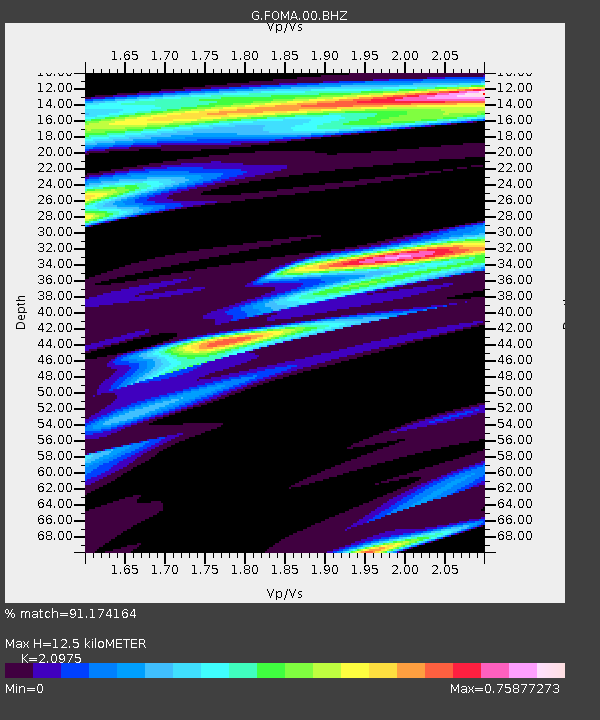
| Estimated Moho Depth: |
12.5 km |
| Estimated Crust Vp/Vs: |
2.10 |
| Assumed Crust Vp: |
6.183 km/s |
| Estimated Crust Vs: |
2.948 km/s |
| Estimated Crust Poisson's Ratio: |
0.35 |
|
| Radial Match: |
91.174164 % |
| Radial Bump: |
251 |
| Transverse Match: |
55.87717 % |
| Transverse Bump: |
400 |
| SOD ConfigId: |
21709731 |
| Insert Time: |
2020-09-01 22:37:58.115 +0000 |
| GWidth: |
2.5 |
| Max Bumps: |
400 |
| Tol: |
0.001 |
|

Signal To Noise
| Channel | StoN | STA | LTA |
| G:FOMA:00:BHZ:20200818T22:38:29.198982Z | 2.8663177 | 2.6391353E-6 | 9.207407E-7 |
| G:FOMA:00:BHN:20200818T22:38:29.198982Z | 1.6197492 | 8.377753E-7 | 5.172254E-7 |
| G:FOMA:00:BHE:20200818T22:38:29.198982Z | 2.2137625 | 1.9927122E-6 | 9.001473E-7 |
| Arrivals |
| Ps | 2.3 SECOND |
| PpPs | 6.0 SECOND |
| PsPs/PpSs | 8.3 SECOND |


