You are here: Home > Network List > IU - Global Seismograph Network (GSN - IRIS/USGS) Stations List
> Station CASY Casey, Antarctica > Earthquake Result Viewer
CASY Casey, Antarctica - Earthquake Result Viewer
| Earthquake location: |
Southern Sumatra, Indonesia |
| Earthquake latitude/longitude: |
-4.3/101.2 |
| Earthquake time(UTC): |
2020/08/18 (231) 22:29:22 GMT |
| Earthquake Depth: |
10 km |
| Earthquake Magnitude: |
6.9 mww |
| Earthquake Catalog/Contributor: |
NEIC PDE/us |
|
| Network: |
IU Global Seismograph Network (GSN - IRIS/USGS) |
| Station: |
CASY Casey, Antarctica |
| Lat/Lon: |
66.28 S/110.54 E |
| Elevation: |
10 m |
|
| Distance: |
62.2 deg |
| Az: |
175.754 deg |
| Baz: |
349.483 deg |
| Ray Param: |
0.06036683 |
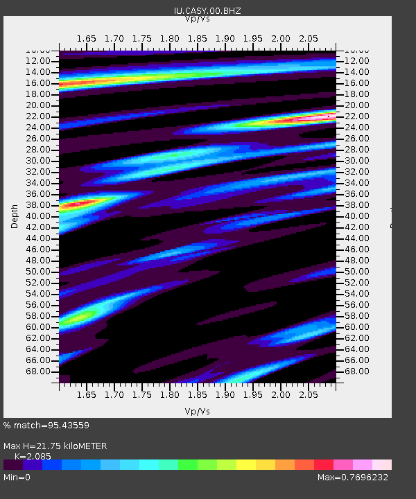
| Estimated Moho Depth: |
21.75 km |
| Estimated Crust Vp/Vs: |
2.09 |
| Assumed Crust Vp: |
6.356 km/s |
| Estimated Crust Vs: |
3.049 km/s |
| Estimated Crust Poisson's Ratio: |
0.35 |
|
| Radial Match: |
95.43559 % |
| Radial Bump: |
400 |
| Transverse Match: |
79.98091 % |
| Transverse Bump: |
400 |
| SOD ConfigId: |
21709731 |
| Insert Time: |
2020-09-01 22:39:02.173 +0000 |
| GWidth: |
2.5 |
| Max Bumps: |
400 |
| Tol: |
0.001 |
|
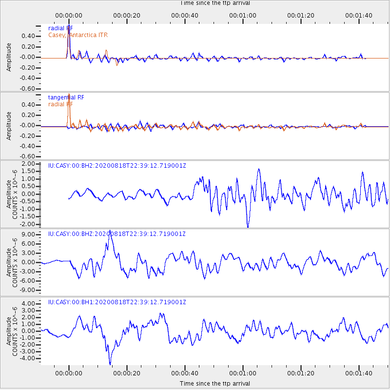
Signal To Noise
| Channel | StoN | STA | LTA |
| IU:CASY:00:BHZ:20200818T22:39:12.719001Z | 4.750289 | 2.4262063E-6 | 5.107492E-7 |
| IU:CASY:00:BH1:20200818T22:39:12.719001Z | 3.462379 | 1.2250024E-6 | 3.5380367E-7 |
| IU:CASY:00:BH2:20200818T22:39:12.719001Z | 1.7532938 | 3.5754115E-7 | 2.0392541E-7 |
| Arrivals |
| Ps | 3.9 SECOND |
| PpPs | 10 SECOND |
| PsPs/PpSs | 14 SECOND |


