You are here: Home > Network List > IU - Global Seismograph Network (GSN - IRIS/USGS) Stations List
> Station JOHN Johnston Island, USA > Earthquake Result Viewer
JOHN Johnston Island, USA - Earthquake Result Viewer
| Earthquake location: |
Southern Sumatra, Indonesia |
| Earthquake latitude/longitude: |
-4.3/101.2 |
| Earthquake time(UTC): |
2020/08/18 (231) 22:29:22 GMT |
| Earthquake Depth: |
10 km |
| Earthquake Magnitude: |
6.9 mww |
| Earthquake Catalog/Contributor: |
NEIC PDE/us |
|
| Network: |
IU Global Seismograph Network (GSN - IRIS/USGS) |
| Station: |
JOHN Johnston Island, USA |
| Lat/Lon: |
16.73 N/169.53 W |
| Elevation: |
2.0 m |
|
| Distance: |
90.5 deg |
| Az: |
73.364 deg |
| Baz: |
265.714 deg |
| Ray Param: |
0.041699387 |
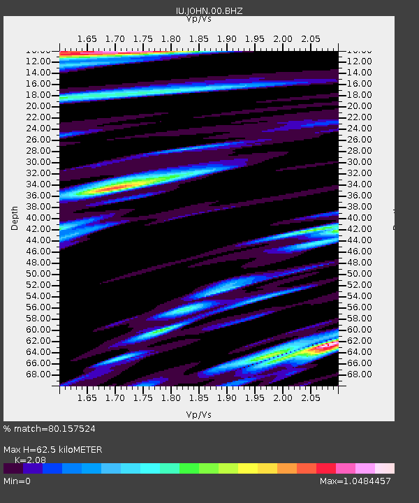
| Estimated Moho Depth: |
62.5 km |
| Estimated Crust Vp/Vs: |
2.08 |
| Assumed Crust Vp: |
4.24 km/s |
| Estimated Crust Vs: |
2.038 km/s |
| Estimated Crust Poisson's Ratio: |
0.35 |
|
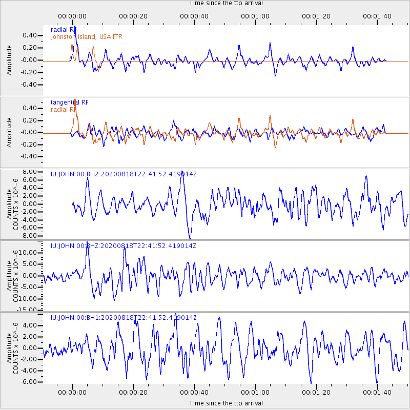
| Radial Match: |
80.157524 % |
| Radial Bump: |
400 |
| Transverse Match: |
77.63664 % |
| Transverse Bump: |
400 |
| SOD ConfigId: |
21709731 |
| Insert Time: |
2020-09-01 22:39:06.971 +0000 |
| GWidth: |
2.5 |
| Max Bumps: |
400 |
| Tol: |
0.001 |
|
Signal To Noise
| Channel | StoN | STA | LTA |
| IU:JOHN:00:BHZ:20200818T22:41:52.419014Z | 3.3022254 | 3.972414E-6 | 1.2029507E-6 |
| IU:JOHN:00:BH1:20200818T22:41:52.419014Z | 0.8614461 | 1.0284095E-6 | 1.1938176E-6 |
| IU:JOHN:00:BH2:20200818T22:41:52.419014Z | 0.97327864 | 1.9591364E-6 | 2.0129244E-6 |
| Arrivals |
| Ps | 16 SECOND |
| PpPs | 45 SECOND |
| PsPs/PpSs | 61 SECOND |


