You are here: Home > Network List > IU - Global Seismograph Network (GSN - IRIS/USGS) Stations List
> Station KIEV Kiev, Ukraine > Earthquake Result Viewer
KIEV Kiev, Ukraine - Earthquake Result Viewer
| Earthquake location: |
Southern Sumatra, Indonesia |
| Earthquake latitude/longitude: |
-4.3/101.2 |
| Earthquake time(UTC): |
2020/08/18 (231) 22:29:22 GMT |
| Earthquake Depth: |
10 km |
| Earthquake Magnitude: |
6.9 mww |
| Earthquake Catalog/Contributor: |
NEIC PDE/us |
|
| Network: |
IU Global Seismograph Network (GSN - IRIS/USGS) |
| Station: |
KIEV Kiev, Ukraine |
| Lat/Lon: |
50.70 N/29.22 E |
| Elevation: |
180 m |
|
| Distance: |
82.0 deg |
| Az: |
322.362 deg |
| Baz: |
106.73 deg |
| Ray Param: |
0.047180053 |
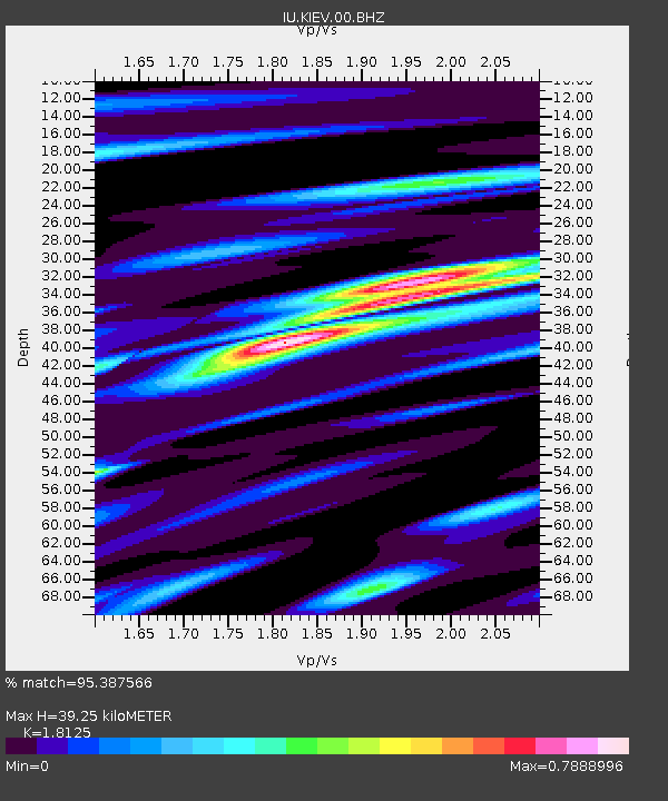
| Estimated Moho Depth: |
39.25 km |
| Estimated Crust Vp/Vs: |
1.81 |
| Assumed Crust Vp: |
6.552 km/s |
| Estimated Crust Vs: |
3.615 km/s |
| Estimated Crust Poisson's Ratio: |
0.28 |
|
| Radial Match: |
95.387566 % |
| Radial Bump: |
399 |
| Transverse Match: |
86.412346 % |
| Transverse Bump: |
400 |
| SOD ConfigId: |
21709731 |
| Insert Time: |
2020-09-01 22:39:12.340 +0000 |
| GWidth: |
2.5 |
| Max Bumps: |
400 |
| Tol: |
0.001 |
|

Signal To Noise
| Channel | StoN | STA | LTA |
| IU:KIEV:00:BHZ:20200818T22:41:10.818977Z | 6.537291 | 4.691727E-6 | 7.1768676E-7 |
| IU:KIEV:00:BH1:20200818T22:41:10.818977Z | 2.5538034 | 4.6874052E-7 | 1.8354605E-7 |
| IU:KIEV:00:BH2:20200818T22:41:10.818977Z | 3.942936 | 1.4459697E-6 | 3.6672412E-7 |
| Arrivals |
| Ps | 5.0 SECOND |
| PpPs | 16 SECOND |
| PsPs/PpSs | 21 SECOND |


