You are here: Home > Network List > KR - Kyrgyz Digital Network Stations List
> Station BOOM Boom, Kyrgyzstan > Earthquake Result Viewer
BOOM Boom, Kyrgyzstan - Earthquake Result Viewer

| Earthquake location: |
Southern Sumatra, Indonesia |
| Earthquake latitude/longitude: |
-4.3/101.2 |
| Earthquake time(UTC): |
2020/08/18 (231) 22:29:22 GMT |
| Earthquake Depth: |
10 km |
| Earthquake Magnitude: |
6.9 mww |
| Earthquake Catalog/Contributor: |
NEIC PDE/us |
|
| Network: |
KR Kyrgyz Digital Network |
| Station: |
BOOM Boom, Kyrgyzstan |
| Lat/Lon: |
42.49 N/75.94 E |
| Elevation: |
1737 m |
|
| Distance: |
51.9 deg |
| Az: |
336.338 deg |
| Baz: |
147.24 deg |
| Ray Param: |
0.06711764 |
| Estimated Moho Depth: |
39.0 km |
| Estimated Crust Vp/Vs: |
1.92 |
| Assumed Crust Vp: |
6.306 km/s |
| Estimated Crust Vs: |
3.28 km/s |
| Estimated Crust Poisson's Ratio: |
0.31 |
|
| Radial Match: |
90.459785 % |
| Radial Bump: |
400 |
| Transverse Match: |
84.360596 % |
| Transverse Bump: |
400 |
| SOD ConfigId: |
21709731 |
| Insert Time: |
2020-09-01 22:40:07.346 +0000 |
| GWidth: |
2.5 |
| Max Bumps: |
400 |
| Tol: |
0.001 |
|
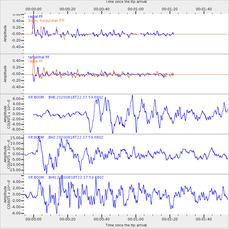
Signal To Noise
| Channel | StoN | STA | LTA |
| KR:BOOM: :BHZ:20200818T22:37:59.680Z | 9.317363 | 7.886412E-6 | 8.464211E-7 |
| KR:BOOM: :BHN:20200818T22:37:59.680Z | 4.251264 | 2.1402034E-6 | 5.0342754E-7 |
| KR:BOOM: :BHE:20200818T22:37:59.680Z | 5.3448567 | 3.3660351E-6 | 6.297709E-7 |
| Arrivals |
| Ps | 6.0 SECOND |
| PpPs | 17 SECOND |
| PsPs/PpSs | 23 SECOND |


