You are here: Home > Network List > KR - Kyrgyz Digital Network Stations List
> Station DRK Karamyk, Kyrgyzstan > Earthquake Result Viewer
DRK Karamyk, Kyrgyzstan - Earthquake Result Viewer
| Earthquake location: |
Southern Sumatra, Indonesia |
| Earthquake latitude/longitude: |
-4.3/101.2 |
| Earthquake time(UTC): |
2020/08/18 (231) 22:29:22 GMT |
| Earthquake Depth: |
10 km |
| Earthquake Magnitude: |
6.9 mww |
| Earthquake Catalog/Contributor: |
NEIC PDE/us |
|
| Network: |
KR Kyrgyz Digital Network |
| Station: |
DRK Karamyk, Kyrgyzstan |
| Lat/Lon: |
39.48 N/71.80 E |
| Elevation: |
2627 m |
|
| Distance: |
51.3 deg |
| Az: |
330.849 deg |
| Baz: |
141.122 deg |
| Ray Param: |
0.06751355 |
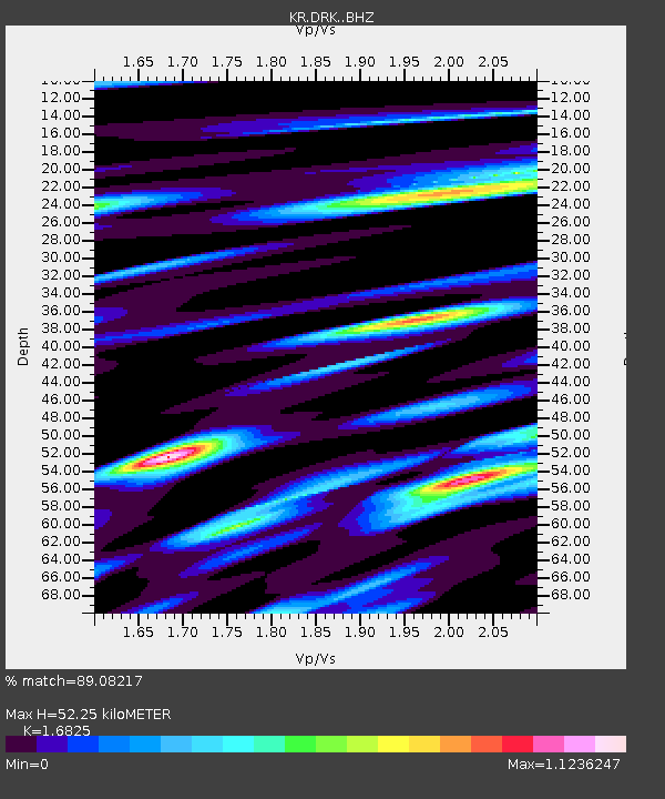
| Estimated Moho Depth: |
52.25 km |
| Estimated Crust Vp/Vs: |
1.68 |
| Assumed Crust Vp: |
6.306 km/s |
| Estimated Crust Vs: |
3.748 km/s |
| Estimated Crust Poisson's Ratio: |
0.23 |
|
| Radial Match: |
89.08217 % |
| Radial Bump: |
400 |
| Transverse Match: |
51.477448 % |
| Transverse Bump: |
400 |
| SOD ConfigId: |
21709731 |
| Insert Time: |
2020-09-01 22:40:10.269 +0000 |
| GWidth: |
2.5 |
| Max Bumps: |
400 |
| Tol: |
0.001 |
|

Signal To Noise
| Channel | StoN | STA | LTA |
| KR:DRK: :BHZ:20200818T22:37:55.15998Z | 11.782806 | 8.330191E-6 | 7.0697854E-7 |
| KR:DRK: :BHN:20200818T22:37:55.15998Z | 4.9627957 | 3.2871078E-6 | 6.6235003E-7 |
| KR:DRK: :BHE:20200818T22:37:55.15998Z | 5.4401817 | 2.399063E-6 | 4.4098954E-7 |
| Arrivals |
| Ps | 6.0 SECOND |
| PpPs | 21 SECOND |
| PsPs/PpSs | 27 SECOND |


