You are here: Home > Network List > WY - Yellowstone Wyoming Seismic Network Stations List
> Station YMR Madison River, YNP, WY, USA > Earthquake Result Viewer
YMR Madison River, YNP, WY, USA - Earthquake Result Viewer
| Earthquake location: |
North Atlantic Ocean |
| Earthquake latitude/longitude: |
13.4/-49.4 |
| Earthquake time(UTC): |
2017/07/27 (208) 17:53:25 GMT |
| Earthquake Depth: |
10 km |
| Earthquake Magnitude: |
5.9 Mww |
| Earthquake Catalog/Contributor: |
NEIC PDE/us |
|
| Network: |
WY Yellowstone Wyoming Seismic Network |
| Station: |
YMR Madison River, YNP, WY, USA |
| Lat/Lon: |
44.67 N/110.96 W |
| Elevation: |
2149 m |
|
| Distance: |
60.6 deg |
| Az: |
313.89 deg |
| Baz: |
100.603 deg |
| Ray Param: |
0.061448243 |
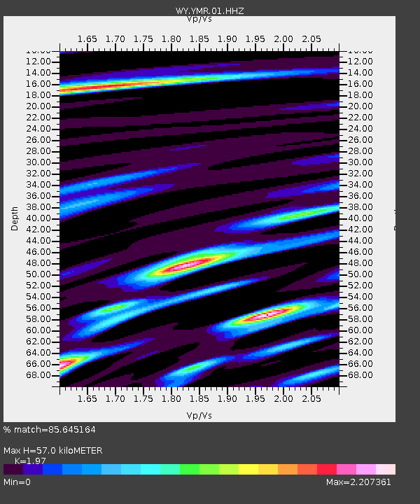
| Estimated Moho Depth: |
57.0 km |
| Estimated Crust Vp/Vs: |
1.97 |
| Assumed Crust Vp: |
6.35 km/s |
| Estimated Crust Vs: |
3.223 km/s |
| Estimated Crust Poisson's Ratio: |
0.33 |
|
| Radial Match: |
85.645164 % |
| Radial Bump: |
400 |
| Transverse Match: |
78.64432 % |
| Transverse Bump: |
400 |
| SOD ConfigId: |
2140511 |
| Insert Time: |
2017-08-10 09:51:06.705 +0000 |
| GWidth: |
2.5 |
| Max Bumps: |
400 |
| Tol: |
0.001 |
|

Signal To Noise
| Channel | StoN | STA | LTA |
| WY:YMR:01:HHZ:20170727T18:03:04.44802Z | 6.447623 | 1.1727315E-8 | 1.8188588E-9 |
| WY:YMR:01:HHN:20170727T18:03:04.44802Z | 0.6651653 | 2.6620204E-9 | 4.002043E-9 |
| WY:YMR:01:HHE:20170727T18:03:04.44802Z | 2.0958562 | 6.5583037E-9 | 3.1291763E-9 |
| Arrivals |
| Ps | 9.1 SECOND |
| PpPs | 26 SECOND |
| PsPs/PpSs | 35 SECOND |


