You are here: Home > Network List > KR - Kyrgyz Digital Network Stations List
> Station OHH Osh,Kyrgyzstan > Earthquake Result Viewer
OHH Osh,Kyrgyzstan - Earthquake Result Viewer
| Earthquake location: |
Southern Sumatra, Indonesia |
| Earthquake latitude/longitude: |
-4.3/101.2 |
| Earthquake time(UTC): |
2020/08/18 (231) 22:29:22 GMT |
| Earthquake Depth: |
10 km |
| Earthquake Magnitude: |
6.9 mww |
| Earthquake Catalog/Contributor: |
NEIC PDE/us |
|
| Network: |
KR Kyrgyz Digital Network |
| Station: |
OHH Osh,Kyrgyzstan |
| Lat/Lon: |
40.53 N/72.78 E |
| Elevation: |
800 m |
|
| Distance: |
51.7 deg |
| Az: |
332.433 deg |
| Baz: |
142.736 deg |
| Ray Param: |
0.06727922 |
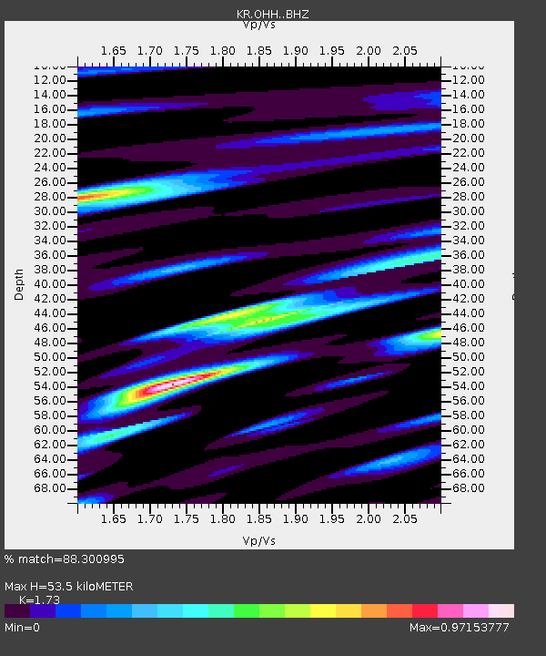
| Estimated Moho Depth: |
53.5 km |
| Estimated Crust Vp/Vs: |
1.73 |
| Assumed Crust Vp: |
6.306 km/s |
| Estimated Crust Vs: |
3.645 km/s |
| Estimated Crust Poisson's Ratio: |
0.25 |
|
| Radial Match: |
88.300995 % |
| Radial Bump: |
400 |
| Transverse Match: |
76.046646 % |
| Transverse Bump: |
400 |
| SOD ConfigId: |
21709731 |
| Insert Time: |
2020-09-01 22:40:17.252 +0000 |
| GWidth: |
2.5 |
| Max Bumps: |
400 |
| Tol: |
0.001 |
|

Signal To Noise
| Channel | StoN | STA | LTA |
| KR:OHH: :BHZ:20200818T22:37:57.82502Z | 8.296712 | 7.4754935E-6 | 9.0101884E-7 |
| KR:OHH: :BHN:20200818T22:37:57.82502Z | 5.442739 | 2.4962592E-6 | 4.5864024E-7 |
| KR:OHH: :BHE:20200818T22:37:57.82502Z | 3.268918 | 2.0488008E-6 | 6.2675196E-7 |
| Arrivals |
| Ps | 6.5 SECOND |
| PpPs | 22 SECOND |
| PsPs/PpSs | 28 SECOND |


