You are here: Home > Network List > TA - USArray Transportable Network (new EarthScope stations) Stations List
> Station C16K Lisburne Hills, AK, USA > Earthquake Result Viewer
C16K Lisburne Hills, AK, USA - Earthquake Result Viewer
| Earthquake location: |
Southern Sumatra, Indonesia |
| Earthquake latitude/longitude: |
-4.3/101.2 |
| Earthquake time(UTC): |
2020/08/18 (231) 22:29:22 GMT |
| Earthquake Depth: |
10 km |
| Earthquake Magnitude: |
6.9 mww |
| Earthquake Catalog/Contributor: |
NEIC PDE/us |
|
| Network: |
TA USArray Transportable Network (new EarthScope stations) |
| Station: |
C16K Lisburne Hills, AK, USA |
| Lat/Lon: |
68.27 N/165.34 W |
| Elevation: |
102 m |
|
| Distance: |
95.2 deg |
| Az: |
21.912 deg |
| Baz: |
271.609 deg |
| Ray Param: |
0.040848874 |
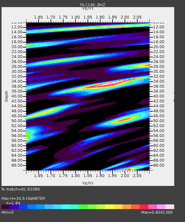
| Estimated Moho Depth: |
34.5 km |
| Estimated Crust Vp/Vs: |
1.94 |
| Assumed Crust Vp: |
5.906 km/s |
| Estimated Crust Vs: |
3.045 km/s |
| Estimated Crust Poisson's Ratio: |
0.32 |
|
| Radial Match: |
81.93398 % |
| Radial Bump: |
400 |
| Transverse Match: |
77.76836 % |
| Transverse Bump: |
400 |
| SOD ConfigId: |
21709731 |
| Insert Time: |
2020-09-01 22:41:56.477 +0000 |
| GWidth: |
2.5 |
| Max Bumps: |
400 |
| Tol: |
0.001 |
|
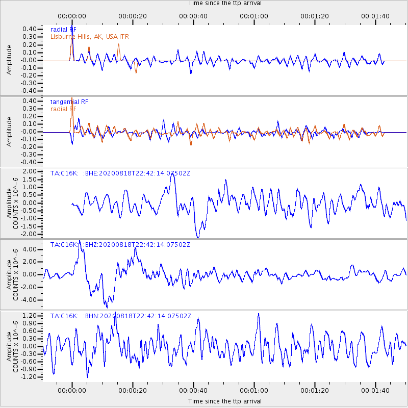
Signal To Noise
| Channel | StoN | STA | LTA |
| TA:C16K: :BHZ:20200818T22:42:14.07502Z | 6.652423 | 2.8390439E-6 | 4.267684E-7 |
| TA:C16K: :BHN:20200818T22:42:14.07502Z | 0.9768639 | 3.8795713E-7 | 3.9714556E-7 |
| TA:C16K: :BHE:20200818T22:42:14.07502Z | 2.604473 | 1.1375681E-6 | 4.3677474E-7 |
| Arrivals |
| Ps | 5.6 SECOND |
| PpPs | 17 SECOND |
| PsPs/PpSs | 22 SECOND |


