You are here: Home > Network List > TA - USArray Transportable Network (new EarthScope stations) Stations List
> Station H16K Elim, AK, USA > Earthquake Result Viewer
H16K Elim, AK, USA - Earthquake Result Viewer
| Earthquake location: |
Southern Sumatra, Indonesia |
| Earthquake latitude/longitude: |
-4.3/101.2 |
| Earthquake time(UTC): |
2020/08/18 (231) 22:29:22 GMT |
| Earthquake Depth: |
10 km |
| Earthquake Magnitude: |
6.9 mww |
| Earthquake Catalog/Contributor: |
NEIC PDE/us |
|
| Network: |
TA USArray Transportable Network (new EarthScope stations) |
| Station: |
H16K Elim, AK, USA |
| Lat/Lon: |
64.64 N/162.24 W |
| Elevation: |
216 m |
|
| Distance: |
96.7 deg |
| Az: |
25.517 deg |
| Baz: |
274.08 deg |
| Ray Param: |
0.04045396 |
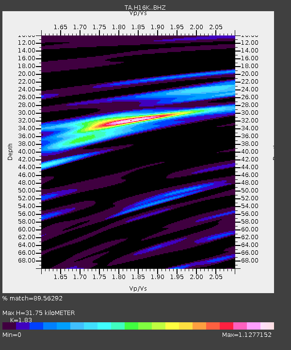
| Estimated Moho Depth: |
31.75 km |
| Estimated Crust Vp/Vs: |
1.83 |
| Assumed Crust Vp: |
6.276 km/s |
| Estimated Crust Vs: |
3.429 km/s |
| Estimated Crust Poisson's Ratio: |
0.29 |
|
| Radial Match: |
89.56292 % |
| Radial Bump: |
400 |
| Transverse Match: |
75.884575 % |
| Transverse Bump: |
400 |
| SOD ConfigId: |
21709731 |
| Insert Time: |
2020-09-01 22:42:22.652 +0000 |
| GWidth: |
2.5 |
| Max Bumps: |
400 |
| Tol: |
0.001 |
|
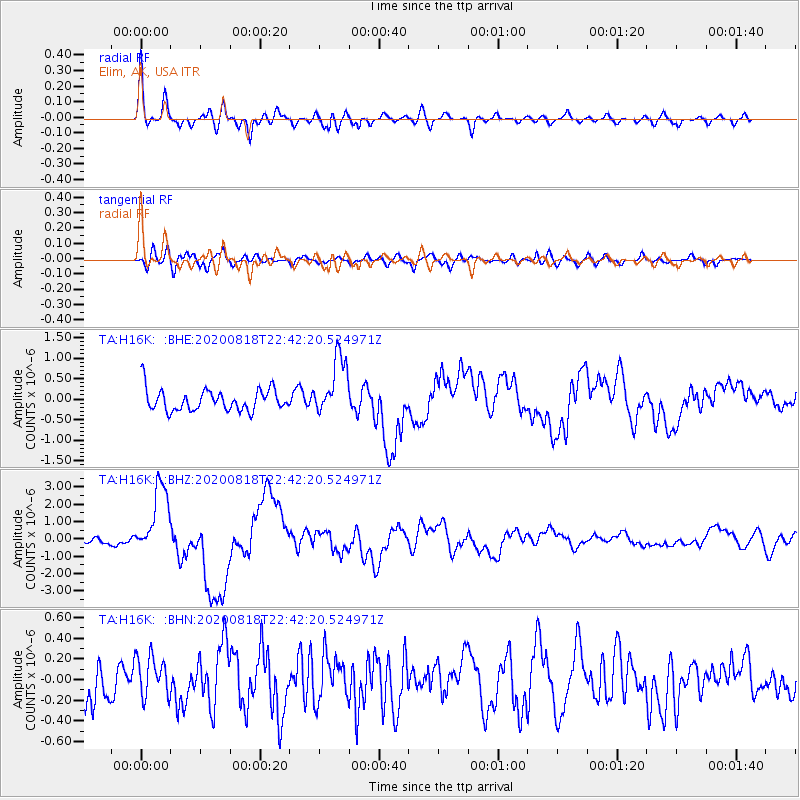
Signal To Noise
| Channel | StoN | STA | LTA |
| TA:H16K: :BHZ:20200818T22:42:20.524971Z | 7.1335797 | 2.0495322E-6 | 2.8730767E-7 |
| TA:H16K: :BHN:20200818T22:42:20.524971Z | 1.2110072 | 1.982869E-7 | 1.6373718E-7 |
| TA:H16K: :BHE:20200818T22:42:20.524971Z | 2.7354634 | 7.180084E-7 | 2.6248142E-7 |
| Arrivals |
| Ps | 4.3 SECOND |
| PpPs | 14 SECOND |
| PsPs/PpSs | 18 SECOND |


