You are here: Home > Network List > TA - USArray Transportable Network (new EarthScope stations) Stations List
> Station I17K Unalakleet, AK, USA > Earthquake Result Viewer
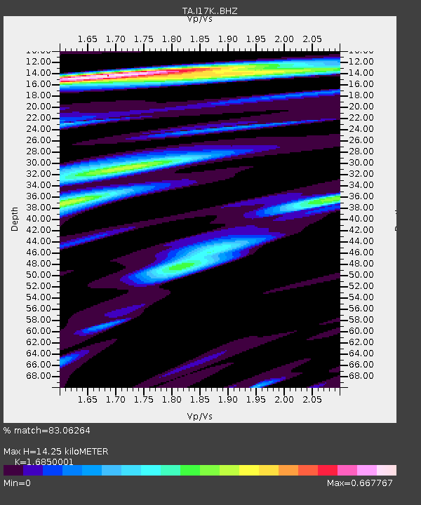
I17K Unalakleet, AK, USA - Earthquake Result Viewer
| Earthquake location: |
Southern Sumatra, Indonesia |
| Earthquake latitude/longitude: |
-4.3/101.2 |
| Earthquake time(UTC): |
2020/08/18 (231) 22:29:22 GMT |
| Earthquake Depth: |
10 km |
| Earthquake Magnitude: |
6.9 mww |
| Earthquake Catalog/Contributor: |
NEIC PDE/us |
|
| Network: |
TA USArray Transportable Network (new EarthScope stations) |
| Station: |
I17K Unalakleet, AK, USA |
| Lat/Lon: |
63.89 N/160.70 W |
| Elevation: |
105 m |
|
| Distance: |
97.4 deg |
| Az: |
26.219 deg |
| Baz: |
275.384 deg |
| Ray Param: |
0.0402334 |
| Estimated Moho Depth: |
14.25 km |
| Estimated Crust Vp/Vs: |
1.69 |
| Assumed Crust Vp: |
6.276 km/s |
| Estimated Crust Vs: |
3.725 km/s |
| Estimated Crust Poisson's Ratio: |
0.23 |
|
| Radial Match: |
83.06264 % |
| Radial Bump: |
400 |
| Transverse Match: |
78.00854 % |
| Transverse Bump: |
400 |
| SOD ConfigId: |
21709731 |
| Insert Time: |
2020-09-01 22:42:25.634 +0000 |
| GWidth: |
2.5 |
| Max Bumps: |
400 |
| Tol: |
0.001 |
|

Signal To Noise
| Channel | StoN | STA | LTA |
| TA:I17K: :BHZ:20200818T22:42:23.799995Z | 7.1500044 | 2.402463E-6 | 3.3600858E-7 |
| TA:I17K: :BHN:20200818T22:42:23.799995Z | 1.4426931 | 2.4963865E-7 | 1.7303655E-7 |
| TA:I17K: :BHE:20200818T22:42:23.799995Z | 1.2637173 | 3.831274E-7 | 3.0317494E-7 |
| Arrivals |
| Ps | 1.6 SECOND |
| PpPs | 6.0 SECOND |
| PsPs/PpSs | 7.6 SECOND |


