You are here: Home > Network List > TA - USArray Transportable Network (new EarthScope stations) Stations List
> Station K15K Wolf Creek Mountain, AK, USA > Earthquake Result Viewer
K15K Wolf Creek Mountain, AK, USA - Earthquake Result Viewer
| Earthquake location: |
Southern Sumatra, Indonesia |
| Earthquake latitude/longitude: |
-4.3/101.2 |
| Earthquake time(UTC): |
2020/08/18 (231) 22:29:22 GMT |
| Earthquake Depth: |
10 km |
| Earthquake Magnitude: |
6.9 mww |
| Earthquake Catalog/Contributor: |
NEIC PDE/us |
|
| Network: |
TA USArray Transportable Network (new EarthScope stations) |
| Station: |
K15K Wolf Creek Mountain, AK, USA |
| Lat/Lon: |
62.29 N/161.53 W |
| Elevation: |
346 m |
|
| Distance: |
97.1 deg |
| Az: |
27.858 deg |
| Baz: |
274.432 deg |
| Ray Param: |
0.040307384 |
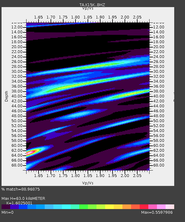
| Estimated Moho Depth: |
63.0 km |
| Estimated Crust Vp/Vs: |
1.60 |
| Assumed Crust Vp: |
6.276 km/s |
| Estimated Crust Vs: |
3.916 km/s |
| Estimated Crust Poisson's Ratio: |
0.18 |
|
| Radial Match: |
88.96875 % |
| Radial Bump: |
353 |
| Transverse Match: |
73.73451 % |
| Transverse Bump: |
400 |
| SOD ConfigId: |
21709731 |
| Insert Time: |
2020-09-01 22:42:31.389 +0000 |
| GWidth: |
2.5 |
| Max Bumps: |
400 |
| Tol: |
0.001 |
|

Signal To Noise
| Channel | StoN | STA | LTA |
| TA:K15K: :BHZ:20200818T22:42:22.724983Z | 5.9235992 | 2.3484154E-6 | 3.9645073E-7 |
| TA:K15K: :BHN:20200818T22:42:22.724983Z | 1.0839522 | 1.8607223E-7 | 1.7166091E-7 |
| TA:K15K: :BHE:20200818T22:42:22.724983Z | 2.3774426 | 7.457955E-7 | 3.1369652E-7 |
| Arrivals |
| Ps | 6.2 SECOND |
| PpPs | 26 SECOND |
| PsPs/PpSs | 32 SECOND |


