You are here: Home > Network List > AK - Alaska Regional Network Stations List
> Station P16K Nushagak River, AK, USA > Earthquake Result Viewer
P16K Nushagak River, AK, USA - Earthquake Result Viewer
| Earthquake location: |
Banda Sea |
| Earthquake latitude/longitude: |
-6.7/123.5 |
| Earthquake time(UTC): |
2020/08/21 (234) 04:09:52 GMT |
| Earthquake Depth: |
627 km |
| Earthquake Magnitude: |
6.9 mww |
| Earthquake Catalog/Contributor: |
NEIC PDE/us |
|
| Network: |
AK Alaska Regional Network |
| Station: |
P16K Nushagak River, AK, USA |
| Lat/Lon: |
59.03 N/157.99 W |
| Elevation: |
86 m |
|
| Distance: |
89.8 deg |
| Az: |
30.448 deg |
| Baz: |
256.766 deg |
| Ray Param: |
0.041487966 |
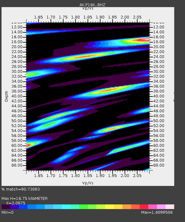
| Estimated Moho Depth: |
16.75 km |
| Estimated Crust Vp/Vs: |
2.10 |
| Assumed Crust Vp: |
6.276 km/s |
| Estimated Crust Vs: |
2.992 km/s |
| Estimated Crust Poisson's Ratio: |
0.35 |
|
| Radial Match: |
90.73893 % |
| Radial Bump: |
400 |
| Transverse Match: |
82.84838 % |
| Transverse Bump: |
400 |
| SOD ConfigId: |
21709731 |
| Insert Time: |
2020-09-04 04:11:46.515 +0000 |
| GWidth: |
2.5 |
| Max Bumps: |
400 |
| Tol: |
0.001 |
|

Signal To Noise
| Channel | StoN | STA | LTA |
| AK:P16K: :BHZ:20200821T04:21:14.260009Z | 39.27025 | 5.902215E-6 | 1.5029737E-7 |
| AK:P16K: :BHN:20200821T04:21:14.260009Z | 3.1438162 | 7.326234E-7 | 2.3303633E-7 |
| AK:P16K: :BHE:20200821T04:21:14.260009Z | 7.3213406 | 1.4406089E-6 | 1.9676845E-7 |
| Arrivals |
| Ps | 3.0 SECOND |
| PpPs | 8.1 SECOND |
| PsPs/PpSs | 11 SECOND |


