You are here: Home > Network List > AV - Alaska Volcano Observatory Stations List
> Station GALA Lava Point, Gareloi Volcano, Alaska > Earthquake Result Viewer
GALA Lava Point, Gareloi Volcano, Alaska - Earthquake Result Viewer
| Earthquake location: |
Banda Sea |
| Earthquake latitude/longitude: |
-6.7/123.5 |
| Earthquake time(UTC): |
2020/08/21 (234) 04:09:52 GMT |
| Earthquake Depth: |
627 km |
| Earthquake Magnitude: |
6.9 mww |
| Earthquake Catalog/Contributor: |
NEIC PDE/us |
|
| Network: |
AV Alaska Volcano Observatory |
| Station: |
GALA Lava Point, Gareloi Volcano, Alaska |
| Lat/Lon: |
51.76 N/178.77 W |
| Elevation: |
315 m |
|
| Distance: |
76.2 deg |
| Az: |
32.769 deg |
| Baz: |
239.887 deg |
| Ray Param: |
0.049133677 |
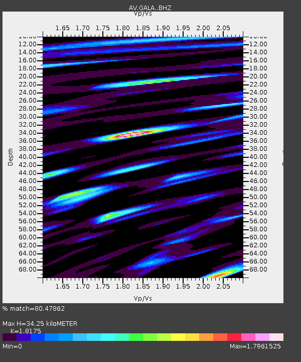
| Estimated Moho Depth: |
34.25 km |
| Estimated Crust Vp/Vs: |
1.82 |
| Assumed Crust Vp: |
6.048 km/s |
| Estimated Crust Vs: |
3.328 km/s |
| Estimated Crust Poisson's Ratio: |
0.28 |
|
| Radial Match: |
80.47862 % |
| Radial Bump: |
400 |
| Transverse Match: |
82.48089 % |
| Transverse Bump: |
400 |
| SOD ConfigId: |
21709731 |
| Insert Time: |
2020-09-04 04:13:38.628 +0000 |
| GWidth: |
2.5 |
| Max Bumps: |
400 |
| Tol: |
0.001 |
|

Signal To Noise
| Channel | StoN | STA | LTA |
| AV:GALA: :BHZ:20200821T04:20:06.559997Z | 84.839966 | 1.5669315E-5 | 1.8469262E-7 |
| AV:GALA: :BHN:20200821T04:20:06.559997Z | 21.954893 | 7.639072E-6 | 3.4794394E-7 |
| AV:GALA: :BHE:20200821T04:20:06.559997Z | 22.548042 | 8.879846E-6 | 3.938189E-7 |
| Arrivals |
| Ps | 4.7 SECOND |
| PpPs | 16 SECOND |
| PsPs/PpSs | 20 SECOND |


