You are here: Home > Network List > AV - Alaska Volcano Observatory Stations List
> Station GASW Southwest, Gareloi Volcano, Alaska > Earthquake Result Viewer
GASW Southwest, Gareloi Volcano, Alaska - Earthquake Result Viewer
| Earthquake location: |
Banda Sea |
| Earthquake latitude/longitude: |
-6.7/123.5 |
| Earthquake time(UTC): |
2020/08/21 (234) 04:09:52 GMT |
| Earthquake Depth: |
627 km |
| Earthquake Magnitude: |
6.9 mww |
| Earthquake Catalog/Contributor: |
NEIC PDE/us |
|
| Network: |
AV Alaska Volcano Observatory |
| Station: |
GASW Southwest, Gareloi Volcano, Alaska |
| Lat/Lon: |
51.78 N/178.86 W |
| Elevation: |
248 m |
|
| Distance: |
76.1 deg |
| Az: |
32.726 deg |
| Baz: |
239.812 deg |
| Ray Param: |
0.04915676 |
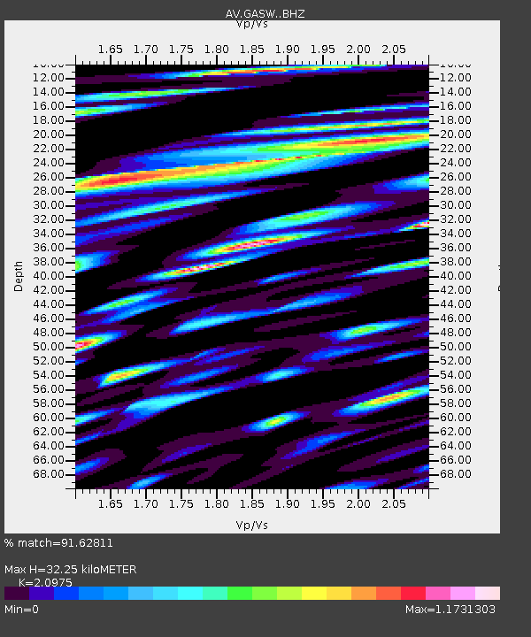
| Estimated Moho Depth: |
32.25 km |
| Estimated Crust Vp/Vs: |
2.10 |
| Assumed Crust Vp: |
6.048 km/s |
| Estimated Crust Vs: |
2.883 km/s |
| Estimated Crust Poisson's Ratio: |
0.35 |
|
| Radial Match: |
91.62811 % |
| Radial Bump: |
400 |
| Transverse Match: |
91.14989 % |
| Transverse Bump: |
400 |
| SOD ConfigId: |
21709731 |
| Insert Time: |
2020-09-04 04:13:42.748 +0000 |
| GWidth: |
2.5 |
| Max Bumps: |
400 |
| Tol: |
0.001 |
|

Signal To Noise
| Channel | StoN | STA | LTA |
| AV:GASW: :BHZ:20200821T04:20:06.379027Z | 89.36104 | 1.1641724E-5 | 1.302774E-7 |
| AV:GASW: :BHN:20200821T04:20:06.379027Z | 30.064734 | 6.9980906E-6 | 2.3276742E-7 |
| AV:GASW: :BHE:20200821T04:20:06.379027Z | 23.943605 | 5.478211E-6 | 2.2879641E-7 |
| Arrivals |
| Ps | 6.0 SECOND |
| PpPs | 16 SECOND |
| PsPs/PpSs | 22 SECOND |


