You are here: Home > Network List > AV - Alaska Volcano Observatory Stations List
> Station KICM Cape Miga, Kanaga Volcano, Alaska > Earthquake Result Viewer
KICM Cape Miga, Kanaga Volcano, Alaska - Earthquake Result Viewer
| Earthquake location: |
Banda Sea |
| Earthquake latitude/longitude: |
-6.7/123.5 |
| Earthquake time(UTC): |
2020/08/21 (234) 04:09:52 GMT |
| Earthquake Depth: |
627 km |
| Earthquake Magnitude: |
6.9 mww |
| Earthquake Catalog/Contributor: |
NEIC PDE/us |
|
| Network: |
AV Alaska Volcano Observatory |
| Station: |
KICM Cape Miga, Kanaga Volcano, Alaska |
| Lat/Lon: |
51.92 N/177.20 W |
| Elevation: |
183 m |
|
| Distance: |
77.1 deg |
| Az: |
33.122 deg |
| Baz: |
241.205 deg |
| Ray Param: |
0.048531353 |
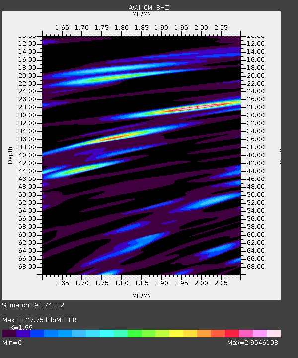
| Estimated Moho Depth: |
27.75 km |
| Estimated Crust Vp/Vs: |
1.99 |
| Assumed Crust Vp: |
5.88 km/s |
| Estimated Crust Vs: |
2.955 km/s |
| Estimated Crust Poisson's Ratio: |
0.33 |
|
| Radial Match: |
91.74112 % |
| Radial Bump: |
400 |
| Transverse Match: |
86.25475 % |
| Transverse Bump: |
400 |
| SOD ConfigId: |
21709731 |
| Insert Time: |
2020-09-04 04:14:00.077 +0000 |
| GWidth: |
2.5 |
| Max Bumps: |
400 |
| Tol: |
0.001 |
|

Signal To Noise
| Channel | StoN | STA | LTA |
| AV:KICM: :BHZ:20200821T04:20:11.599975Z | 116.76451 | 1.4284701E-5 | 1.223377E-7 |
| AV:KICM: :BHN:20200821T04:20:11.599975Z | 13.883097 | 3.298195E-6 | 2.3756913E-7 |
| AV:KICM: :BHE:20200821T04:20:11.599975Z | 32.539585 | 5.499781E-6 | 1.6901815E-7 |
| Arrivals |
| Ps | 4.8 SECOND |
| PpPs | 14 SECOND |
| PsPs/PpSs | 19 SECOND |


