You are here: Home > Network List > AV - Alaska Volcano Observatory Stations List
> Station KIWB Westway Bight, Kanaga Volcano, Alaska > Earthquake Result Viewer
KIWB Westway Bight, Kanaga Volcano, Alaska - Earthquake Result Viewer
| Earthquake location: |
Banda Sea |
| Earthquake latitude/longitude: |
-6.7/123.5 |
| Earthquake time(UTC): |
2020/08/21 (234) 04:09:52 GMT |
| Earthquake Depth: |
627 km |
| Earthquake Magnitude: |
6.9 mww |
| Earthquake Catalog/Contributor: |
NEIC PDE/us |
|
| Network: |
AV Alaska Volcano Observatory |
| Station: |
KIWB Westway Bight, Kanaga Volcano, Alaska |
| Lat/Lon: |
51.85 N/177.15 W |
| Elevation: |
244 m |
|
| Distance: |
77.1 deg |
| Az: |
33.195 deg |
| Baz: |
241.256 deg |
| Ray Param: |
0.04853627 |
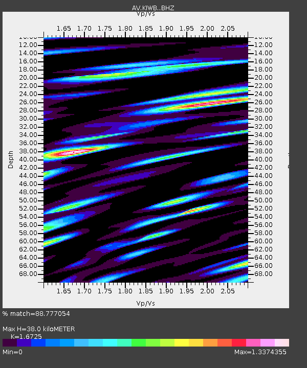
| Estimated Moho Depth: |
38.0 km |
| Estimated Crust Vp/Vs: |
1.67 |
| Assumed Crust Vp: |
5.88 km/s |
| Estimated Crust Vs: |
3.516 km/s |
| Estimated Crust Poisson's Ratio: |
0.22 |
|
| Radial Match: |
88.777054 % |
| Radial Bump: |
400 |
| Transverse Match: |
84.83559 % |
| Transverse Bump: |
400 |
| SOD ConfigId: |
21709731 |
| Insert Time: |
2020-09-04 04:14:06.060 +0000 |
| GWidth: |
2.5 |
| Max Bumps: |
400 |
| Tol: |
0.001 |
|

Signal To Noise
| Channel | StoN | STA | LTA |
| AV:KIWB: :BHZ:20200821T04:20:11.559997Z | 173.79025 | 1.4351833E-5 | 8.2581344E-8 |
| AV:KIWB: :BHN:20200821T04:20:11.559997Z | 40.996212 | 4.334966E-6 | 1.0574064E-7 |
| AV:KIWB: :BHE:20200821T04:20:11.559997Z | 35.986263 | 3.3775714E-6 | 9.385724E-8 |
| Arrivals |
| Ps | 4.5 SECOND |
| PpPs | 17 SECOND |
| PsPs/PpSs | 21 SECOND |


