You are here: Home > Network List > G - GEOSCOPE Stations List
> Station KIP Kipapa, Hawai, U.S.A. (Pacific Ocean) > Earthquake Result Viewer
KIP Kipapa, Hawai, U.S.A. (Pacific Ocean) - Earthquake Result Viewer
| Earthquake location: |
Banda Sea |
| Earthquake latitude/longitude: |
-6.7/123.5 |
| Earthquake time(UTC): |
2020/08/21 (234) 04:09:52 GMT |
| Earthquake Depth: |
627 km |
| Earthquake Magnitude: |
6.9 mww |
| Earthquake Catalog/Contributor: |
NEIC PDE/us |
|
| Network: |
G GEOSCOPE |
| Station: |
KIP Kipapa, Hawai, U.S.A. (Pacific Ocean) |
| Lat/Lon: |
21.42 N/158.01 W |
| Elevation: |
70 m |
|
| Distance: |
81.8 deg |
| Az: |
67.288 deg |
| Baz: |
259.553 deg |
| Ray Param: |
0.045414697 |
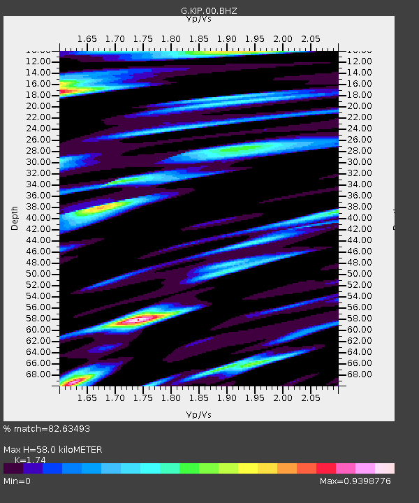
| Estimated Moho Depth: |
58.0 km |
| Estimated Crust Vp/Vs: |
1.74 |
| Assumed Crust Vp: |
4.24 km/s |
| Estimated Crust Vs: |
2.437 km/s |
| Estimated Crust Poisson's Ratio: |
0.25 |
|
| Radial Match: |
82.63493 % |
| Radial Bump: |
400 |
| Transverse Match: |
71.404045 % |
| Transverse Bump: |
400 |
| SOD ConfigId: |
21709731 |
| Insert Time: |
2020-09-04 04:15:35.637 +0000 |
| GWidth: |
2.5 |
| Max Bumps: |
400 |
| Tol: |
0.001 |
|

Signal To Noise
| Channel | StoN | STA | LTA |
| G:KIP:00:BHZ:20200821T04:20:36.119018Z | 8.806694 | 8.041011E-6 | 9.1305674E-7 |
| G:KIP:00:BH1:20200821T04:20:36.119018Z | 2.997402 | 1.9767654E-6 | 6.594929E-7 |
| G:KIP:00:BH2:20200821T04:20:36.119018Z | 4.0046363 | 3.0543035E-6 | 7.6269185E-7 |
| Arrivals |
| Ps | 10 SECOND |
| PpPs | 37 SECOND |
| PsPs/PpSs | 47 SECOND |


