You are here: Home > Network List > MP - Iraqi Seismic Observatory Stations List
> Station NSR4 Nasiriya, Iraq > Earthquake Result Viewer
NSR4 Nasiriya, Iraq - Earthquake Result Viewer
| Earthquake location: |
Banda Sea |
| Earthquake latitude/longitude: |
-6.7/123.5 |
| Earthquake time(UTC): |
2020/08/21 (234) 04:09:52 GMT |
| Earthquake Depth: |
627 km |
| Earthquake Magnitude: |
6.9 mww |
| Earthquake Catalog/Contributor: |
NEIC PDE/us |
|
| Network: |
MP Iraqi Seismic Observatory |
| Station: |
NSR4 Nasiriya, Iraq |
| Lat/Lon: |
31.54 N/46.20 E |
| Elevation: |
7.0 m |
|
| Distance: |
82.7 deg |
| Az: |
302.895 deg |
| Baz: |
102.357 deg |
| Ray Param: |
0.044771776 |
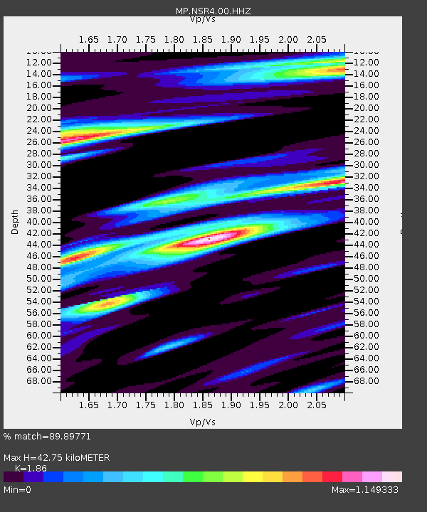
| Estimated Moho Depth: |
42.75 km |
| Estimated Crust Vp/Vs: |
1.86 |
| Assumed Crust Vp: |
6.168 km/s |
| Estimated Crust Vs: |
3.316 km/s |
| Estimated Crust Poisson's Ratio: |
0.30 |
|
| Radial Match: |
89.89771 % |
| Radial Bump: |
400 |
| Transverse Match: |
65.365906 % |
| Transverse Bump: |
400 |
| SOD ConfigId: |
21709731 |
| Insert Time: |
2020-09-04 04:18:39.541 +0000 |
| GWidth: |
2.5 |
| Max Bumps: |
400 |
| Tol: |
0.001 |
|

Signal To Noise
| Channel | StoN | STA | LTA |
| MP:NSR4:00:HHZ:20200821T04:20:40.789977Z | 7.170786 | 3.2774664E-5 | 4.5705815E-6 |
| MP:NSR4:00:HHN:20200821T04:20:40.789977Z | 0.7541971 | 3.4418845E-6 | 4.5636407E-6 |
| MP:NSR4:00:HHE:20200821T04:20:40.789977Z | 1.5520633 | 6.2035747E-6 | 3.9969855E-6 |
| Arrivals |
| Ps | 6.1 SECOND |
| PpPs | 19 SECOND |
| PsPs/PpSs | 25 SECOND |


