You are here: Home > Network List > S1 - Australian Seismometers in Schools Stations List
> Station AUMTS Mt Stromlo > Earthquake Result Viewer
AUMTS Mt Stromlo - Earthquake Result Viewer
| Earthquake location: |
Banda Sea |
| Earthquake latitude/longitude: |
-6.7/123.5 |
| Earthquake time(UTC): |
2020/08/21 (234) 04:09:52 GMT |
| Earthquake Depth: |
627 km |
| Earthquake Magnitude: |
6.9 mww |
| Earthquake Catalog/Contributor: |
NEIC PDE/us |
|
| Network: |
S1 Australian Seismometers in Schools |
| Station: |
AUMTS Mt Stromlo |
| Lat/Lon: |
35.32 S/149.00 E |
| Elevation: |
667 m |
|
| Distance: |
36.9 deg |
| Az: |
144.106 deg |
| Baz: |
314.591 deg |
| Ray Param: |
0.07310706 |
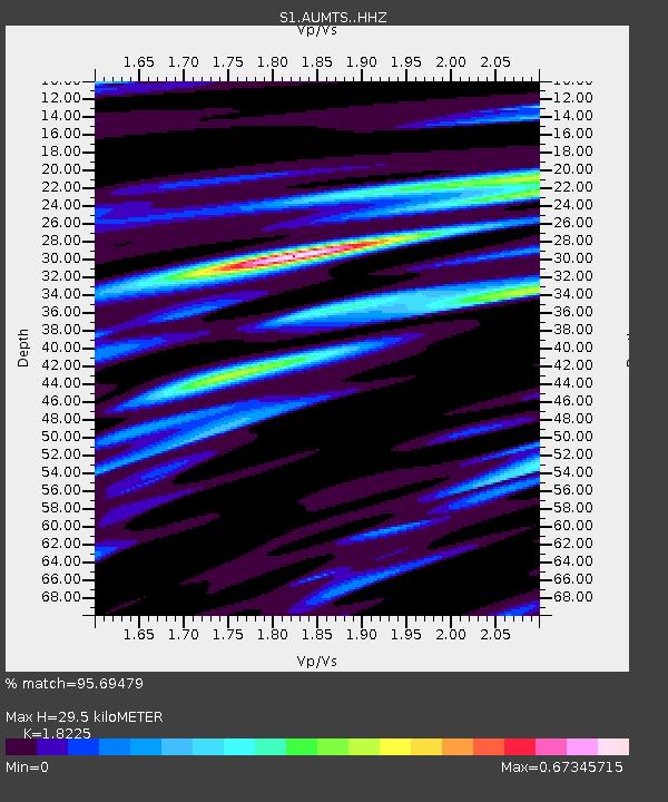
| Estimated Moho Depth: |
29.5 km |
| Estimated Crust Vp/Vs: |
1.82 |
| Assumed Crust Vp: |
6.633 km/s |
| Estimated Crust Vs: |
3.64 km/s |
| Estimated Crust Poisson's Ratio: |
0.28 |
|
| Radial Match: |
95.69479 % |
| Radial Bump: |
267 |
| Transverse Match: |
72.52345 % |
| Transverse Bump: |
400 |
| SOD ConfigId: |
21709731 |
| Insert Time: |
2020-09-04 04:19:24.424 +0000 |
| GWidth: |
2.5 |
| Max Bumps: |
400 |
| Tol: |
0.001 |
|

Signal To Noise
| Channel | StoN | STA | LTA |
| S1:AUMTS: :HHZ:20200821T04:15:39.760009Z | 24.24714 | 2.0297777E-5 | 8.371204E-7 |
| S1:AUMTS: :HHN:20200821T04:15:39.760009Z | 15.543449 | 9.640267E-6 | 6.2021417E-7 |
| S1:AUMTS: :HHE:20200821T04:15:39.760009Z | 9.756578 | 6.2305144E-6 | 6.3859625E-7 |
| Arrivals |
| Ps | 3.9 SECOND |
| PpPs | 12 SECOND |
| PsPs/PpSs | 16 SECOND |


