You are here: Home > Network List > TA - USArray Transportable Network (new EarthScope stations) Stations List
> Station E20K Nigu River, AK, USA > Earthquake Result Viewer
E20K Nigu River, AK, USA - Earthquake Result Viewer
| Earthquake location: |
Banda Sea |
| Earthquake latitude/longitude: |
-6.7/123.5 |
| Earthquake time(UTC): |
2020/08/21 (234) 04:09:52 GMT |
| Earthquake Depth: |
627 km |
| Earthquake Magnitude: |
6.9 mww |
| Earthquake Catalog/Contributor: |
NEIC PDE/us |
|
| Network: |
TA USArray Transportable Network (new EarthScope stations) |
| Station: |
E20K Nigu River, AK, USA |
| Lat/Lon: |
68.26 N/156.19 W |
| Elevation: |
866 m |
|
| Distance: |
92.6 deg |
| Az: |
21.571 deg |
| Baz: |
258.568 deg |
| Ray Param: |
0.040908962 |
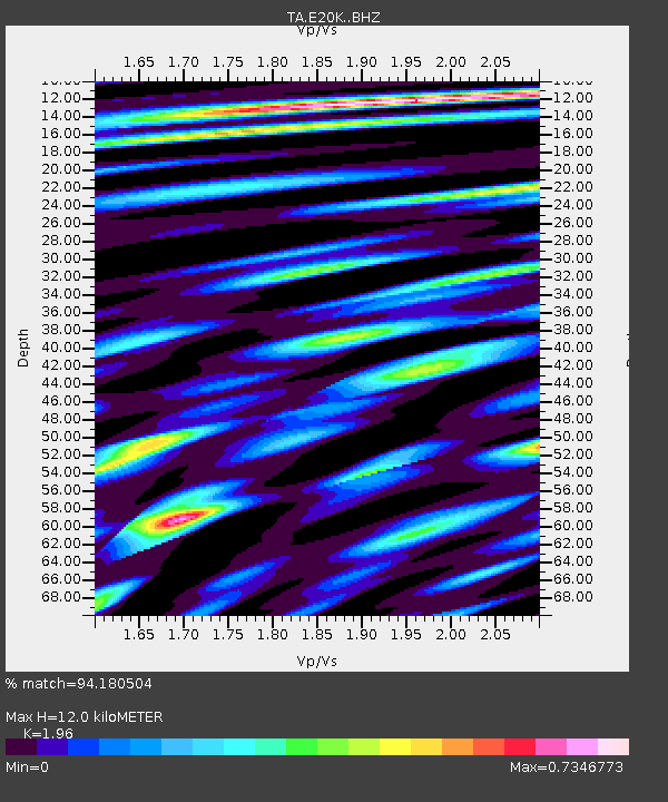
| Estimated Moho Depth: |
12.0 km |
| Estimated Crust Vp/Vs: |
1.96 |
| Assumed Crust Vp: |
6.221 km/s |
| Estimated Crust Vs: |
3.174 km/s |
| Estimated Crust Poisson's Ratio: |
0.32 |
|
| Radial Match: |
94.180504 % |
| Radial Bump: |
400 |
| Transverse Match: |
90.358315 % |
| Transverse Bump: |
400 |
| SOD ConfigId: |
21709731 |
| Insert Time: |
2020-09-04 04:20:06.943 +0000 |
| GWidth: |
2.5 |
| Max Bumps: |
400 |
| Tol: |
0.001 |
|
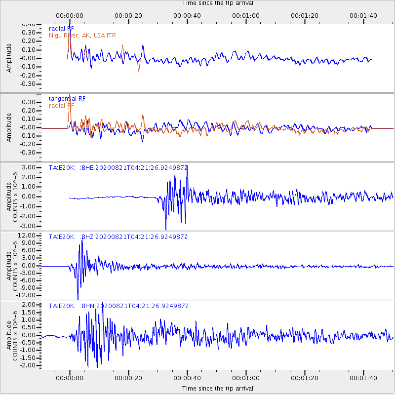
Signal To Noise
| Channel | StoN | STA | LTA |
| TA:E20K: :BHZ:20200821T04:21:26.924987Z | 103.98299 | 4.793899E-6 | 4.6102723E-8 |
| TA:E20K: :BHN:20200821T04:21:26.924987Z | 10.027144 | 4.3241113E-7 | 4.3124054E-8 |
| TA:E20K: :BHE:20200821T04:21:26.924987Z | 13.716726 | 1.042952E-6 | 7.603506E-8 |
| Arrivals |
| Ps | 1.9 SECOND |
| PpPs | 5.6 SECOND |
| PsPs/PpSs | 7.5 SECOND |


