You are here: Home > Network List > TA - USArray Transportable Network (new EarthScope stations) Stations List
> Station F17K Baldwin Penninsula, AK, USA > Earthquake Result Viewer
F17K Baldwin Penninsula, AK, USA - Earthquake Result Viewer
| Earthquake location: |
Banda Sea |
| Earthquake latitude/longitude: |
-6.7/123.5 |
| Earthquake time(UTC): |
2020/08/21 (234) 04:09:52 GMT |
| Earthquake Depth: |
627 km |
| Earthquake Magnitude: |
6.9 mww |
| Earthquake Catalog/Contributor: |
NEIC PDE/us |
|
| Network: |
TA USArray Transportable Network (new EarthScope stations) |
| Station: |
F17K Baldwin Penninsula, AK, USA |
| Lat/Lon: |
66.44 N/161.25 W |
| Elevation: |
51 m |
|
| Distance: |
90.2 deg |
| Az: |
22.874 deg |
| Baz: |
253.868 deg |
| Ray Param: |
0.041414276 |
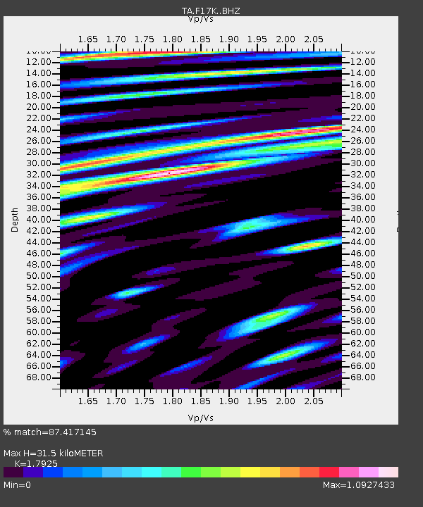
| Estimated Moho Depth: |
31.5 km |
| Estimated Crust Vp/Vs: |
1.79 |
| Assumed Crust Vp: |
6.276 km/s |
| Estimated Crust Vs: |
3.501 km/s |
| Estimated Crust Poisson's Ratio: |
0.27 |
|
| Radial Match: |
87.417145 % |
| Radial Bump: |
400 |
| Transverse Match: |
83.72712 % |
| Transverse Bump: |
400 |
| SOD ConfigId: |
21709731 |
| Insert Time: |
2020-09-04 04:20:16.256 +0000 |
| GWidth: |
2.5 |
| Max Bumps: |
400 |
| Tol: |
0.001 |
|

Signal To Noise
| Channel | StoN | STA | LTA |
| TA:F17K: :BHZ:20200821T04:21:16.249999Z | 40.37086 | 2.7155645E-6 | 6.726546E-8 |
| TA:F17K: :BHN:20200821T04:21:16.249999Z | 12.832823 | 7.341344E-7 | 5.720755E-8 |
| TA:F17K: :BHE:20200821T04:21:16.249999Z | 17.052252 | 8.1688006E-7 | 4.7904525E-8 |
| Arrivals |
| Ps | 4.1 SECOND |
| PpPs | 14 SECOND |
| PsPs/PpSs | 18 SECOND |


