You are here: Home > Network List > TA - USArray Transportable Network (new EarthScope stations) Stations List
> Station F21K Alatna River, AK, USA > Earthquake Result Viewer
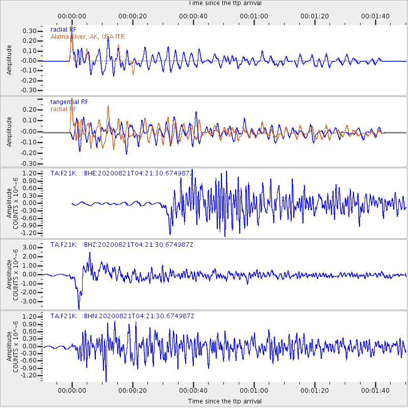
F21K Alatna River, AK, USA - Earthquake Result Viewer
*The percent match for this event was below the threshold and hence no stack was calculated.
| Earthquake location: |
Banda Sea |
| Earthquake latitude/longitude: |
-6.7/123.5 |
| Earthquake time(UTC): |
2020/08/21 (234) 04:09:52 GMT |
| Earthquake Depth: |
627 km |
| Earthquake Magnitude: |
6.9 mww |
| Earthquake Catalog/Contributor: |
NEIC PDE/us |
|
| Network: |
TA USArray Transportable Network (new EarthScope stations) |
| Station: |
F21K Alatna River, AK, USA |
| Lat/Lon: |
67.22 N/153.48 W |
| Elevation: |
597 m |
|
| Distance: |
93.4 deg |
| Az: |
22.779 deg |
| Baz: |
261.007 deg |
| Ray Param: |
$rayparam |
*The percent match for this event was below the threshold and hence was not used in the summary stack. |
|
| Radial Match: |
75.84855 % |
| Radial Bump: |
400 |
| Transverse Match: |
73.74337 % |
| Transverse Bump: |
400 |
| SOD ConfigId: |
21709731 |
| Insert Time: |
2020-09-04 04:20:22.162 +0000 |
| GWidth: |
2.5 |
| Max Bumps: |
400 |
| Tol: |
0.001 |
|
Signal To Noise
| Channel | StoN | STA | LTA |
| TA:F21K: :BHZ:20200821T04:21:30.674987Z | 25.492937 | 1.4814119E-6 | 5.8110682E-8 |
| TA:F21K: :BHN:20200821T04:21:30.674987Z | 8.599813 | 3.0042116E-7 | 3.4933453E-8 |
| TA:F21K: :BHE:20200821T04:21:30.674987Z | 10.274384 | 4.7326137E-7 | 4.6062265E-8 |
| Arrivals |
| Ps | |
| PpPs | |
| PsPs/PpSs | |


