You are here: Home > Network List > TA - USArray Transportable Network (new EarthScope stations) Stations List
> Station O15K Ungalikthiuk River, AK, USA > Earthquake Result Viewer
O15K Ungalikthiuk River, AK, USA - Earthquake Result Viewer
| Earthquake location: |
Banda Sea |
| Earthquake latitude/longitude: |
-6.7/123.5 |
| Earthquake time(UTC): |
2020/08/21 (234) 04:09:52 GMT |
| Earthquake Depth: |
627 km |
| Earthquake Magnitude: |
6.9 mww |
| Earthquake Catalog/Contributor: |
NEIC PDE/us |
|
| Network: |
TA USArray Transportable Network (new EarthScope stations) |
| Station: |
O15K Ungalikthiuk River, AK, USA |
| Lat/Lon: |
59.18 N/159.82 W |
| Elevation: |
306 m |
|
| Distance: |
88.9 deg |
| Az: |
30.078 deg |
| Baz: |
255.191 deg |
| Ray Param: |
0.041613635 |
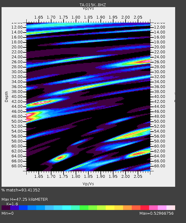
| Estimated Moho Depth: |
47.25 km |
| Estimated Crust Vp/Vs: |
1.60 |
| Assumed Crust Vp: |
6.24 km/s |
| Estimated Crust Vs: |
3.9 km/s |
| Estimated Crust Poisson's Ratio: |
0.18 |
|
| Radial Match: |
93.41352 % |
| Radial Bump: |
400 |
| Transverse Match: |
77.860565 % |
| Transverse Bump: |
400 |
| SOD ConfigId: |
21709731 |
| Insert Time: |
2020-09-04 04:21:15.970 +0000 |
| GWidth: |
2.5 |
| Max Bumps: |
400 |
| Tol: |
0.001 |
|

Signal To Noise
| Channel | StoN | STA | LTA |
| TA:O15K: :BHZ:20200821T04:21:10.174987Z | 49.595345 | 3.172307E-6 | 6.396381E-8 |
| TA:O15K: :BHN:20200821T04:21:10.174987Z | 7.879708 | 3.2803408E-7 | 4.1630233E-8 |
| TA:O15K: :BHE:20200821T04:21:10.174987Z | 23.616102 | 1.141143E-6 | 4.8320548E-8 |
| Arrivals |
| Ps | 4.6 SECOND |
| PpPs | 19 SECOND |
| PsPs/PpSs | 24 SECOND |


