You are here: Home > Network List > TA - USArray Transportable Network (new EarthScope stations) Stations List
> Station S14K Fog Glacier, AK, USA > Earthquake Result Viewer
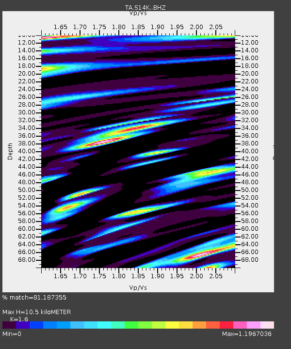
S14K Fog Glacier, AK, USA - Earthquake Result Viewer
| Earthquake location: |
Banda Sea |
| Earthquake latitude/longitude: |
-6.7/123.5 |
| Earthquake time(UTC): |
2020/08/21 (234) 04:09:52 GMT |
| Earthquake Depth: |
627 km |
| Earthquake Magnitude: |
6.9 mww |
| Earthquake Catalog/Contributor: |
NEIC PDE/us |
|
| Network: |
TA USArray Transportable Network (new EarthScope stations) |
| Station: |
S14K Fog Glacier, AK, USA |
| Lat/Lon: |
56.28 N/159.55 W |
| Elevation: |
1059 m |
|
| Distance: |
88.3 deg |
| Az: |
32.921 deg |
| Baz: |
255.488 deg |
| Ray Param: |
0.041675895 |
| Estimated Moho Depth: |
10.5 km |
| Estimated Crust Vp/Vs: |
1.60 |
| Assumed Crust Vp: |
6.134 km/s |
| Estimated Crust Vs: |
3.834 km/s |
| Estimated Crust Poisson's Ratio: |
0.18 |
|
| Radial Match: |
81.187355 % |
| Radial Bump: |
400 |
| Transverse Match: |
79.81034 % |
| Transverse Bump: |
400 |
| SOD ConfigId: |
21709731 |
| Insert Time: |
2020-09-04 04:21:21.906 +0000 |
| GWidth: |
2.5 |
| Max Bumps: |
400 |
| Tol: |
0.001 |
|

Signal To Noise
| Channel | StoN | STA | LTA |
| TA:S14K: :BHZ:20200821T04:21:07.450011Z | 30.147018 | 8.389456E-6 | 2.7828477E-7 |
| TA:S14K: :BHN:20200821T04:21:07.450011Z | 8.8986845 | 4.5424313E-6 | 5.10461E-7 |
| TA:S14K: :BHE:20200821T04:21:07.450011Z | 5.688059 | 2.621744E-6 | 4.609207E-7 |
| Arrivals |
| Ps | 1.0 SECOND |
| PpPs | 4.4 SECOND |
| PsPs/PpSs | 5.4 SECOND |


