You are here: Home > Network List > TA - USArray Transportable Network (new EarthScope stations) Stations List
> Station H16K Elim, AK, USA > Earthquake Result Viewer
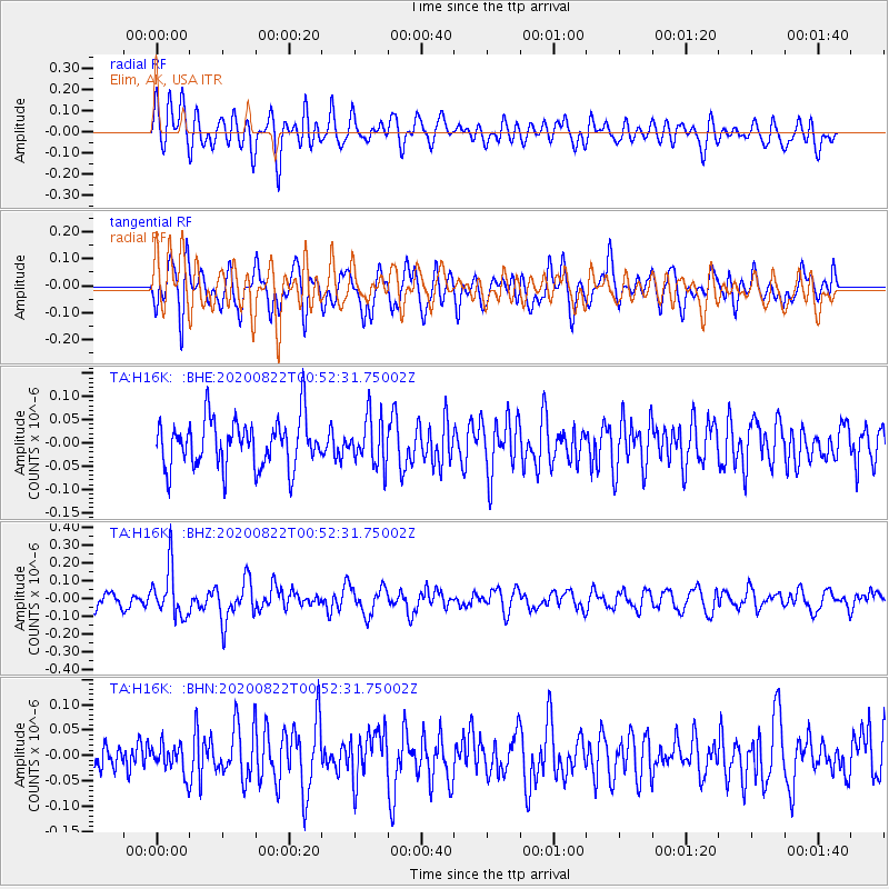
H16K Elim, AK, USA - Earthquake Result Viewer
*The percent match for this event was below the threshold and hence no stack was calculated.
| Earthquake location: |
Southwest Of Sumatra, Indonesia |
| Earthquake latitude/longitude: |
-4.1/101.0 |
| Earthquake time(UTC): |
2020/08/22 (235) 00:39:33 GMT |
| Earthquake Depth: |
10 km |
| Earthquake Magnitude: |
5.4 Mww |
| Earthquake Catalog/Contributor: |
NEIC PDE/us |
|
| Network: |
TA USArray Transportable Network (new EarthScope stations) |
| Station: |
H16K Elim, AK, USA |
| Lat/Lon: |
64.64 N/162.24 W |
| Elevation: |
216 m |
|
| Distance: |
96.6 deg |
| Az: |
25.5 deg |
| Baz: |
274.369 deg |
| Ray Param: |
$rayparam |
*The percent match for this event was below the threshold and hence was not used in the summary stack. |
|
| Radial Match: |
45.856937 % |
| Radial Bump: |
400 |
| Transverse Match: |
57.83103 % |
| Transverse Bump: |
400 |
| SOD ConfigId: |
21709731 |
| Insert Time: |
2020-09-05 00:45:46.969 +0000 |
| GWidth: |
2.5 |
| Max Bumps: |
400 |
| Tol: |
0.001 |
|
Signal To Noise
| Channel | StoN | STA | LTA |
| TA:H16K: :BHZ:20200822T00:52:31.75002Z | 3.2241576 | 1.3571727E-7 | 4.2093873E-8 |
| TA:H16K: :BHN:20200822T00:52:31.75002Z | 0.74206334 | 2.7658544E-8 | 3.7272482E-8 |
| TA:H16K: :BHE:20200822T00:52:31.75002Z | 1.0051317 | 5.1505033E-8 | 5.124207E-8 |
| Arrivals |
| Ps | |
| PpPs | |
| PsPs/PpSs | |


